IMAGES TAKEN NEAR TO
Valencia Grove, PRESCOT, L34 2TS
Introduction
This page details the photographs taken nearby to Valencia Grove, L34 2TS by members of the Geograph project.
The Geograph project started in 2005 with the aim of publishing, organising and preserving representative images for every square kilometre of Great Britain, Ireland and the Isle of Man.

There are currently over 7.5m images from over14,400 individuals and you can help contribute to the project by visiting https://www.geograph.org.uk
Image Map
Images are licensed for reuse under creativecommons.org/licenses/by-sa/2.0
Notes
- Clicking on the map will re-center to the selected point.
- The higher the marker number, the further away the image location is from the centre of the postcode.
Image Listing (9 Images Found)
Images are licensed for reuse under creativecommons.org/licenses/by-sa/2.0
Image
Details
Distance
3
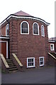
East end, St James church, Eccleston Park
East end showing slight apsidal chancel and cellar beneath.
Image: © S Parish
Taken: 15 Sep 2007
0.21 miles
4
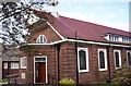
St James, Eccleston Park
Built as Lane End Mission in 1923, this church was consecrated in 1961, a rather superior unlisted church, with an unusual projecting roof over the west end porch.
Image: © S Parish
Taken: 15 Sep 2007
0.21 miles
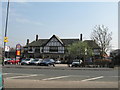
6
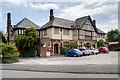
The Grapes Hotel, St Helens Road
Large pub/restaurant/carvery.
Image: © David Dixon
Taken: 21 May 2015
0.22 miles