IMAGES TAKEN NEAR TO
Alder Road, PRESCOT, L34 2SQ
Introduction
This page details the photographs taken nearby to Alder Road, L34 2SQ by members of the Geograph project.
The Geograph project started in 2005 with the aim of publishing, organising and preserving representative images for every square kilometre of Great Britain, Ireland and the Isle of Man.

There are currently over 7.5m images from over14,400 individuals and you can help contribute to the project by visiting https://www.geograph.org.uk
Image Map
Images are licensed for reuse under creativecommons.org/licenses/by-sa/2.0
Notes
- Clicking on the map will re-center to the selected point.
- The higher the marker number, the further away the image location is from the centre of the postcode.
Image Listing (3 Images Found)
Images are licensed for reuse under creativecommons.org/licenses/by-sa/2.0
Image
Details
Distance
1
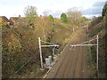
Railway cutting north east of Scotchbarn Lane
Image: © Nigel Thompson
Taken: 10 Nov 2015
0.22 miles

3
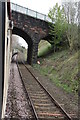
Charter train heads towards Eccleston Park station
Diesel locomotive Class 66/0 number 66138 heads the UK Railtours Olive Branch 2 charter towards the Ribble Steam Railway at Preston having visited the Seaforth Dock (Bootle) branch.
Image: © Roger Templeman
Taken: 14 Apr 2012
0.24 miles