IMAGES TAKEN NEAR TO
Alder Close, PRESCOT, L34 2SN
Introduction
This page details the photographs taken nearby to Alder Close, L34 2SN by members of the Geograph project.
The Geograph project started in 2005 with the aim of publishing, organising and preserving representative images for every square kilometre of Great Britain, Ireland and the Isle of Man.

There are currently over 7.5m images from over14,400 individuals and you can help contribute to the project by visiting https://www.geograph.org.uk
Image Map
Images are licensed for reuse under creativecommons.org/licenses/by-sa/2.0
Notes
- Clicking on the map will re-center to the selected point.
- The higher the marker number, the further away the image location is from the centre of the postcode.
Image Listing (7 Images Found)
Images are licensed for reuse under creativecommons.org/licenses/by-sa/2.0
Image
Details
Distance
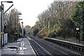
1
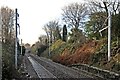
New catenary, Eccleston Park railway station
Looking in the direction of Liverpool. Some new catenary masts have been erected, prior to the electrification of the Liverpool to Wigan line, in 2014.
Image: © El Pollock
Taken: 30 Dec 2013
0.19 miles


4
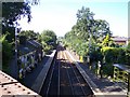
Eccleston Park station from Portico Lane
Image: © Raymond Knapman
Taken: 31 Aug 2010
0.24 miles
5
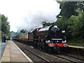
The Cumbrian Mountain Express
A Liverpool Lime Street to Carlisle charter train.
Image: © Peter Dickinson
Taken: 1 Aug 2009
0.24 miles
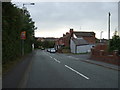
7
End of platforms, Eccleston Park railway station
Looking in the direction of Liverpool. The B5201 Old Lane road bridge is in the distance.
Image: © El Pollock
Taken: 30 Dec 2013
0.25 miles