IMAGES TAKEN NEAR TO
Henrietta Grove, PRESCOT, L34 1PZ
Introduction
This page details the photographs taken nearby to Henrietta Grove, L34 1PZ by members of the Geograph project.
The Geograph project started in 2005 with the aim of publishing, organising and preserving representative images for every square kilometre of Great Britain, Ireland and the Isle of Man.

There are currently over 7.5m images from over14,400 individuals and you can help contribute to the project by visiting https://www.geograph.org.uk
Image Map
Images are licensed for reuse under creativecommons.org/licenses/by-sa/2.0
Notes
- Clicking on the map will re-center to the selected point.
- The higher the marker number, the further away the image location is from the centre of the postcode.
Image Listing (3 Images Found)
Images are licensed for reuse under creativecommons.org/licenses/by-sa/2.0
Image
Details
Distance
1
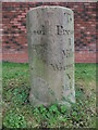
Old Milestone by the A57, Liverpool Road, Huyton-with-Roby
Carved stone post by the A57, in parish of HUYTON WITH ROBY (KNOWSLEY District), Liverpool Road; opposite junction with Lyme Cross Road, on the verge, on South side of road. Old Prescot stone erected by the Liverpool, Prescot, Ashton & Warrington turnpike trust in the 18th century.
Inscription reads:-
: To / Liverpool / Exchange / VII / Miles. : : To / Prescot / 1 / Mile / Warrington XI / Miles :
Grade II listed.
List Entry Number: 1075494 https://historicengland.org.uk/listing/the-list/list-entry/1075494
Milestone Society National ID: LA_WALV11
Image: © M Faherty
Taken: 24 Aug 2008
0.11 miles
2
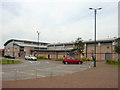
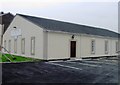
King George V Sports Complex
King George V Sports Complex is situated on Longview Drive close to Huyton Town Centre. It is a community-based centre, used by various local clubs and facilities include, 2 5-a-side astro pitches, 3 all weather tennis courts, 3 under 10's football pitches, 2 junior football pitches, 3 senior football pitches, 2 bowling greens, boxing club and a community hall.
Image: © Sue Adair
Taken: 18 Aug 2005
0.21 miles