IMAGES TAKEN NEAR TO
Kings Drive, PRESCOT, L34 1BH
Introduction
This page details the photographs taken nearby to Kings Drive, L34 1BH by members of the Geograph project.
The Geograph project started in 2005 with the aim of publishing, organising and preserving representative images for every square kilometre of Great Britain, Ireland and the Isle of Man.

There are currently over 7.5m images from over14,400 individuals and you can help contribute to the project by visiting https://www.geograph.org.uk
Image Map
Images are licensed for reuse under creativecommons.org/licenses/by-sa/2.0
Notes
- Clicking on the map will re-center to the selected point.
- The higher the marker number, the further away the image location is from the centre of the postcode.
Image Listing (3 Images Found)
Images are licensed for reuse under creativecommons.org/licenses/by-sa/2.0
Image
Details
Distance
1
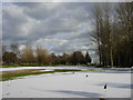
Huyton and Prescot Golf Club
Huyton and Prescot Golf Club (closed due to its covering of snow) is on the former Hurst Park.
Image: © Sue Adair
Taken: 3 Mar 2006
0.14 miles
2
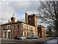
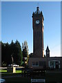
Hurst House, Huyton Lane
Hurst House on Huyton Lane between Huyton and Prescot is now the clubhouse of the Huyton and Prescot Golf Club. Built in 1830, this mansion with its clock tower, was the seat of the Seel family.
Image: © Sue Adair
Taken: 3 Mar 2006
0.16 miles