IMAGES TAKEN NEAR TO
Sugar Lane, PRESCOT, L34 0ES
Introduction
This page details the photographs taken nearby to Sugar Lane, L34 0ES by members of the Geograph project.
The Geograph project started in 2005 with the aim of publishing, organising and preserving representative images for every square kilometre of Great Britain, Ireland and the Isle of Man.

There are currently over 7.5m images from over14,400 individuals and you can help contribute to the project by visiting https://www.geograph.org.uk
Image Map
Images are licensed for reuse under creativecommons.org/licenses/by-sa/2.0
Notes
- Clicking on the map will re-center to the selected point.
- The higher the marker number, the further away the image location is from the centre of the postcode.
Image Listing (6 Images Found)
Images are licensed for reuse under creativecommons.org/licenses/by-sa/2.0
Image
Details
Distance
1
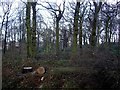
Copse at end of Ormskirk Road, Knowsley Village
Image: © Tom Pennington
Taken: 12 Feb 2007
0.19 miles
5
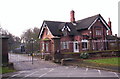
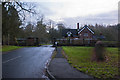
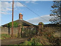
Home Farm, Knowsley Estate
Situated at the western side of Knowsley Park, safe within the walls of Lord Derby's 2,500 acre estate, Home Farm has changed little since it was built. It lies behind a gated entrance, guarded by Home Farm Lodge (Image) and is still a working farm, producing quality Aberdeen Angus beef and Suffolk cross sheep. There is also a microbrewery attached to the farm producing cask-conditioned beers.
Image: © Sue Adair
Taken: 20 Nov 2006
0.24 miles