IMAGES TAKEN NEAR TO
Hammond Road, LIVERPOOL, L33 7UW
Introduction
This page details the photographs taken nearby to Hammond Road, L33 7UW by members of the Geograph project.
The Geograph project started in 2005 with the aim of publishing, organising and preserving representative images for every square kilometre of Great Britain, Ireland and the Isle of Man.

There are currently over 7.5m images from over14,400 individuals and you can help contribute to the project by visiting https://www.geograph.org.uk
Image Map
Images are licensed for reuse under creativecommons.org/licenses/by-sa/2.0
Notes
- Clicking on the map will re-center to the selected point.
- The higher the marker number, the further away the image location is from the centre of the postcode.
Image Listing (4 Images Found)
Images are licensed for reuse under creativecommons.org/licenses/by-sa/2.0
Image
Details
Distance
1
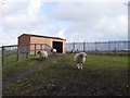
Acorn Venture Urban Farm
Preganant ewes at Acorn Venture Urban Farm, new lambs due at the end of March.
Image: © Sue Adair
Taken: 17 Feb 2006
0.05 miles
2
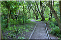
The Acorn Venture Farm - Acorns Woodland Walk
Image: © Ian Greig
Taken: 4 May 2012
0.22 miles
3
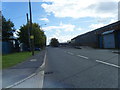
Acornfield Road, Knowsley Industrial Park
Image: © Colin Pyle
Taken: 17 Sep 2010
0.23 miles