IMAGES TAKEN NEAR TO
Apollo Crescent, LIVERPOOL, L33 1YR
Introduction
This page details the photographs taken nearby to Apollo Crescent, L33 1YR by members of the Geograph project.
The Geograph project started in 2005 with the aim of publishing, organising and preserving representative images for every square kilometre of Great Britain, Ireland and the Isle of Man.

There are currently over 7.5m images from over14,400 individuals and you can help contribute to the project by visiting https://www.geograph.org.uk
Image Map
Images are licensed for reuse under creativecommons.org/licenses/by-sa/2.0
Notes
- Clicking on the map will re-center to the selected point.
- The higher the marker number, the further away the image location is from the centre of the postcode.
Image Listing (15 Images Found)
Images are licensed for reuse under creativecommons.org/licenses/by-sa/2.0
Image
Details
Distance
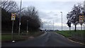
2
The A506 at Tower Hill Kirkby
Viewed from Kirkby to Manchester train
Image: © Raymond Knapman
Taken: 28 Apr 2011
0.06 miles
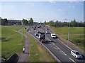
3
A506 County Road passes under the Kirkby-Wigan railway
Image: © Colin Pyle
Taken: 2 Jul 2012
0.12 miles
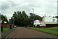
4
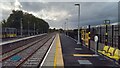
Headbolt Lane station - the line to Liverpool
Image: © Peter Whatley
Taken: 19 Oct 2023
0.13 miles
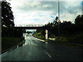
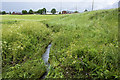
5

A walkway under the road with a footbridge beyond
Image: © Ian Greig
Taken: 15 Jun 2012
0.14 miles
8
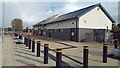
Headbolt Lane - the station building
The brand new structure contains toilets and a booking office, despite contemporary (2023) plans to close all such offices.
Image: © Peter Whatley
Taken: 19 Oct 2023
0.19 miles
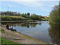
10
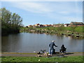
Pond, Mill Lane, Kirkby
The 1891 map shows Kirkby Mill just north of Mill Lane, it was demolished in the 1950's. It appears to have created a mill pond of 1.337 acres and the outlet discharged southwards via Mill Brook, passing the church of St. Chad, eventually to drain into the River Alt. It is now a popular fishing spot for local residents.
Image: © Sue Adair
Taken: 11 Apr 2009
0.22 miles