IMAGES TAKEN NEAR TO
Hosta Close, LIVERPOOL, L33 1SR
Introduction
This page details the photographs taken nearby to Hosta Close, L33 1SR by members of the Geograph project.
The Geograph project started in 2005 with the aim of publishing, organising and preserving representative images for every square kilometre of Great Britain, Ireland and the Isle of Man.

There are currently over 7.5m images from over14,400 individuals and you can help contribute to the project by visiting https://www.geograph.org.uk
Image Map
Images are licensed for reuse under creativecommons.org/licenses/by-sa/2.0
Notes
- Clicking on the map will re-center to the selected point.
- The higher the marker number, the further away the image location is from the centre of the postcode.
Image Listing (6 Images Found)
Images are licensed for reuse under creativecommons.org/licenses/by-sa/2.0
Image
Details
Distance
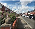
2
Terraced Housing on Windermere Drive
Image: © Anthony Parkes
Taken: 26 Aug 2023
0.16 miles
3
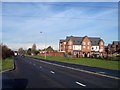
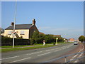
New housing on Bank Lane near Melling Mount
Image: © Raymond Knapman
Taken: 15 Nov 2010
0.16 miles
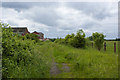
4
Farm Cottage, Shevington's Lane, Kirkby
Previously in the rural wilds of Lancashire this farm cottage is now surrounded by Tower Hill estate, Kirkby.
Image: © Sue Adair
Taken: 16 Oct 2005
0.18 miles
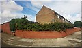
5
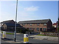
"The Barn" Shevington's Lane, Kirkby
A community centre and nursery housed in converted farm buildings in Shevington's Lane, Kirkby.
Image: © Sue Adair
Taken: 16 Oct 2005
0.18 miles