IMAGES TAKEN NEAR TO
Bracknell Avenue, LIVERPOOL, L32 9PP
Introduction
This page details the photographs taken nearby to Bracknell Avenue, L32 9PP by members of the Geograph project.
The Geograph project started in 2005 with the aim of publishing, organising and preserving representative images for every square kilometre of Great Britain, Ireland and the Isle of Man.

There are currently over 7.5m images from over14,400 individuals and you can help contribute to the project by visiting https://www.geograph.org.uk
Image Map
Images are licensed for reuse under creativecommons.org/licenses/by-sa/2.0
Notes
- Clicking on the map will re-center to the selected point.
- The higher the marker number, the further away the image location is from the centre of the postcode.
Image Listing (6 Images Found)
Images are licensed for reuse under creativecommons.org/licenses/by-sa/2.0
Image
Details
Distance
1
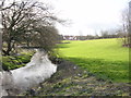
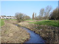
Kirkby Brook looking South
Kirkby Brook joins Mill Brook and flows into the River Alt. The photograph was taken looking south near Bewley Drive which was originally called Cat Tail Lane where there was a farm of the same name. The houses in the background are in Westvale on the other side of Valley Road.
Image: © Sue Adair
Taken: 15 Feb 2006
0.15 miles
3
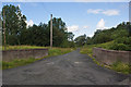
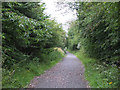
Little Brook Lane
A hidden nook, close to a Motorway and a built up area
Image: © Ian Greig
Taken: 20 Jul 2012
0.19 miles
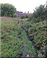
4
A footpath to Knowsley Brook
For braver souls than I on a day like this
Image: © Ian Greig
Taken: 13 Jul 2012
0.20 miles
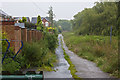
6
Kirkby Brook
The linear parkland along Kirkby Brook looking north from Bewley Drive to the houses on Valley Road (A506)
Image: © Sue Adair
Taken: 15 Feb 2006
0.25 miles