IMAGES TAKEN NEAR TO
Pondwater Close, LIVERPOOL, L32 9BD
Introduction
This page details the photographs taken nearby to Pondwater Close, L32 9BD by members of the Geograph project.
The Geograph project started in 2005 with the aim of publishing, organising and preserving representative images for every square kilometre of Great Britain, Ireland and the Isle of Man.

There are currently over 7.5m images from over14,400 individuals and you can help contribute to the project by visiting https://www.geograph.org.uk
Image Map
Images are licensed for reuse under creativecommons.org/licenses/by-sa/2.0
Notes
- Clicking on the map will re-center to the selected point.
- The higher the marker number, the further away the image location is from the centre of the postcode.
Image Listing (8 Images Found)
Images are licensed for reuse under creativecommons.org/licenses/by-sa/2.0
Image
Details
Distance
1
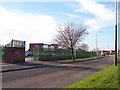
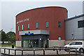
St Joseph The Worker Primary School on Bewley Drive
Image: © Raymond Knapman
Taken: 15 Nov 2010
0.06 miles
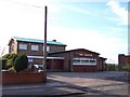
4
The Falcon, Kirkby
Public house on Bewley Drive, Kirkby
Image: © Eirian Evans
Taken: 20 May 2016
0.13 miles
5
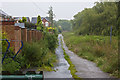
A footpath to Knowsley Brook
For braver souls than I on a day like this
Image: © Ian Greig
Taken: 13 Jul 2012
0.21 miles
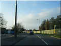
7
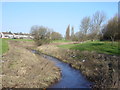
Kirkby Brook
The linear parkland along Kirkby Brook looking north from Bewley Drive to the houses on Valley Road (A506)
Image: © Sue Adair
Taken: 15 Feb 2006
0.25 miles
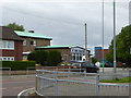
8
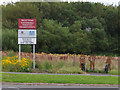
Bench and Sign on Valley Road near Kirkby Brook
Image: © Gary Rogers
Taken: 20 Aug 2017
0.25 miles