IMAGES TAKEN NEAR TO
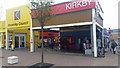
Webster Drive, LIVERPOOL, L32 8SJ
Introduction
This page details the photographs taken nearby to Webster Drive, L32 8SJ by members of the Geograph project.
The Geograph project started in 2005 with the aim of publishing, organising and preserving representative images for every square kilometre of Great Britain, Ireland and the Isle of Man.

There are currently over 7.5m images from over14,400 individuals and you can help contribute to the project by visiting https://www.geograph.org.uk
Image Map
Images are licensed for reuse under creativecommons.org/licenses/by-sa/2.0
Notes
- Clicking on the map will re-center to the selected point.
- The higher the marker number, the further away the image location is from the centre of the postcode.
Image Listing (16 Images Found)
Images are licensed for reuse under creativecommons.org/licenses/by-sa/2.0
Image
Details
Distance
1
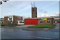
Kirkby fire station
Kirkby fire station, Webster Drive, Kirkby, Merseyside.
Image: © Kevin Hale
Taken: 23 Oct 2006
0.06 miles
3
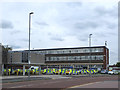
St Chad's Health Centre
St Chad's Health Centre offers GP surgeries, various community services such as children's dental services and a NHS Walk-in Centre offering treatment for minor illnesses and injuries without an appointment.
Image: © Sue Adair
Taken: 8 Jul 2014
0.08 miles
5
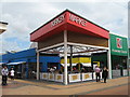
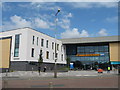
The new Kirkby Market
Opened in March 2014, the brand new Kirkby Market has with 130 stalls and will be open from 9am-4:30pm, Monday to Saturday. The original market opened in 1960 and served the newly built town centre, it had many stalls selling local produce from the surrounding farms and was an open market, the new site has a roof covering all the stalls and cafe.
Image: © Sue Adair
Taken: 8 Jul 2014
0.11 miles
7
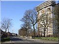
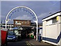
Old Rough Lane, Kirkby
Looking west down Old Rough Lane which was named after the wooded area called Old Rough. The tower block to the right is Oak Tower, its flats are now being sold privately. Nearby, at the junction of Old Rough Lane with County Road (originally School Lane), stood an old Church of England school which was pulled down in the early 1970s. This school was erected in 1806 and until the 1950s was the only school in Kirkby.
Image: © Sue Adair
Taken: 15 Feb 2006
0.13 miles

9
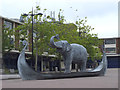
Longboat and elephant, public artwork in Kirkby
http://www.knowsley.gov.uk/residents/regenerate-knowsley/kirkby/public-art
Image: © Gary Rogers
Taken: 20 Aug 2017
0.15 miles
10
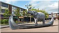
Elephant in a longboat, Kirkby
Inspired by the short nonsense poem by Edward Lear entitled The Enthusiastic Elephant, with the boat represented by a Viking longship to mark Kirkby's Viking heritage ('by' is a Norse suffix meaning a village).
Image: © Mike Pennington
Taken: 23 Aug 2017
0.21 miles