IMAGES TAKEN NEAR TO
Cherry Gardens, LIVERPOOL, L32 7SE
Introduction
This page details the photographs taken nearby to Cherry Gardens, L32 7SE by members of the Geograph project.
The Geograph project started in 2005 with the aim of publishing, organising and preserving representative images for every square kilometre of Great Britain, Ireland and the Isle of Man.

There are currently over 7.5m images from over14,400 individuals and you can help contribute to the project by visiting https://www.geograph.org.uk
Image Map
Images are licensed for reuse under creativecommons.org/licenses/by-sa/2.0
Notes
- Clicking on the map will re-center to the selected point.
- The higher the marker number, the further away the image location is from the centre of the postcode.
Image Listing (11 Images Found)
Images are licensed for reuse under creativecommons.org/licenses/by-sa/2.0
Image
Details
Distance
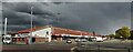
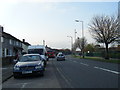
3
Pedestrian crossing on Bewley Drive, Kirkby
Image: © Gary Rogers
Taken: 20 Aug 2017
0.05 miles
5
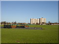
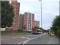
Wignall Park, Southdene, Kirkby
Skateboard area in Wignall Park, Southdene, Kirkby with the tower blocks of Gaywood Avenue in the background.
Image: © Sue Adair
Taken: 15 Feb 2006
0.11 miles
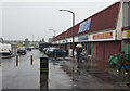
6
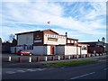
The Kingfisher flies the flag on Bewley Drive
Liverpool Football Club flag shows the allegiance of the pub
Image: © Raymond Knapman
Taken: 15 Nov 2010
0.12 miles
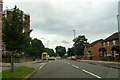
10
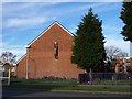
Sculpture on gable end of St Joseph The Worker church
Image: © Raymond Knapman
Taken: 15 Nov 2010
0.19 miles