IMAGES TAKEN NEAR TO
Hunt Road, LIVERPOOL, L31 6BN
Introduction
This page details the photographs taken nearby to Hunt Road, L31 6BN by members of the Geograph project.
The Geograph project started in 2005 with the aim of publishing, organising and preserving representative images for every square kilometre of Great Britain, Ireland and the Isle of Man.

There are currently over 7.5m images from over14,400 individuals and you can help contribute to the project by visiting https://www.geograph.org.uk
Image Map
Images are licensed for reuse under creativecommons.org/licenses/by-sa/2.0
Notes
- Clicking on the map will re-center to the selected point.
- The higher the marker number, the further away the image location is from the centre of the postcode.
Image Listing (14 Images Found)
Images are licensed for reuse under creativecommons.org/licenses/by-sa/2.0
Image
Details
Distance
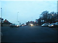
1
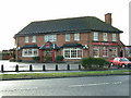
The Everest
On the corner of Eastway and Tenzing Road. Easy to find just go over The Khumba Icefall and left at the Lhotse Ridge.
Image: © Peter Hodge
Taken: 3 Jan 2006
0.12 miles
5
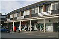
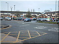
The Square, Maghull
Intended as the main shopping centre for the expanding commuter town of Maghull, it is still a busy shopping area with no empty units - even for the former Woolworth's has been reoccupied.
Image: © Mike Pennington
Taken: 23 Jul 2009
0.22 miles
6
Maghull C of E school
Erected 1830, it says on the sign.
Image: © Mike Pennington
Taken: 11 Jul 2007
0.23 miles
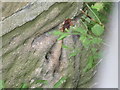
7
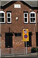
WWII Lancashire: Leeds & Liverpool Canal: Maghull (4)
-
Loopholed Wall: DoB ID: S0011741
At the rear of a Maghull solicitor's car park is a loopholed wall overlooking the canal, all 8 of its embrasures have been blocked, although their concrete lintels remain in situ.
Image
Image: © Mike Searle
Taken: 17 May 2018
0.24 miles
8
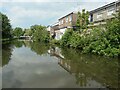
Looking north towards Shaw's Swingbridge [no 14], Maghull
Past the rear of shops and businesses on Liverpool Road North.
Image: © Christine Johnstone
Taken: 27 May 2021
0.24 miles
10
Bench mark and bolt on Red Lion Bridge, Maghull
This 1GL Ordnance Survey bench mark and bolt is on the south east buttress of Red Lion Bridge over the Leeds-Liverpool Canal. Whilst it must have been accessible in the 1850s when it was cut, today it is only possible to see it low down and at an angle from the modern footbridge.
Image: © John S Turner
Taken: 23 Aug 2017
0.24 miles