IMAGES TAKEN NEAR TO
Northway, LIVERPOOL, L31 6BH
Introduction
This page details the photographs taken nearby to Northway, L31 6BH by members of the Geograph project.
The Geograph project started in 2005 with the aim of publishing, organising and preserving representative images for every square kilometre of Great Britain, Ireland and the Isle of Man.

There are currently over 7.5m images from over14,400 individuals and you can help contribute to the project by visiting https://www.geograph.org.uk
Image Map
Images are licensed for reuse under creativecommons.org/licenses/by-sa/2.0
Notes
- Clicking on the map will re-center to the selected point.
- The higher the marker number, the further away the image location is from the centre of the postcode.
Image Listing (6 Images Found)
Images are licensed for reuse under creativecommons.org/licenses/by-sa/2.0
Image
Details
Distance
4
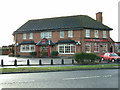
The Everest
On the corner of Eastway and Tenzing Road. Easy to find just go over The Khumba Icefall and left at the Lhotse Ridge.
Image: © Peter Hodge
Taken: 3 Jan 2006
0.24 miles
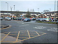
5
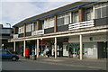
The Square, Maghull
Intended as the main shopping centre for the expanding commuter town of Maghull, it is still a busy shopping area with no empty units - even for the former Woolworth's has been reoccupied.
Image: © Mike Pennington
Taken: 23 Jul 2009
0.24 miles
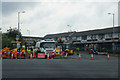
6
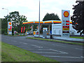
Shell Service Station, Northway, Lydiate
Unleaded 113.9 pence per litre, Diesel 115.9 pence per litre
Image: © Gary Rogers
Taken: 11 Jun 2017
0.25 miles