IMAGES TAKEN NEAR TO
Croftfield, LIVERPOOL, L31 6AE
Introduction
This page details the photographs taken nearby to Croftfield, L31 6AE by members of the Geograph project.
The Geograph project started in 2005 with the aim of publishing, organising and preserving representative images for every square kilometre of Great Britain, Ireland and the Isle of Man.

There are currently over 7.5m images from over14,400 individuals and you can help contribute to the project by visiting https://www.geograph.org.uk
Image Map
Images are licensed for reuse under creativecommons.org/licenses/by-sa/2.0
Notes
- Clicking on the map will re-center to the selected point.
- The higher the marker number, the further away the image location is from the centre of the postcode.
Image Listing (6 Images Found)
Images are licensed for reuse under creativecommons.org/licenses/by-sa/2.0
Image
Details
Distance
2
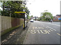
Bus stop and shelter on Foxhouse Lane, Maghull
Looking west.
Image: © JThomas
Taken: 28 Apr 2019
0.18 miles
3
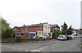
The Fox public house, Maghull
On Foxhouse Lane.
Image: © JThomas
Taken: 28 Apr 2019
0.18 miles
4

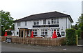
Sign for the Fox public house, Maghull
See Image] for context.
Image: © JThomas
Taken: 28 Apr 2019
0.18 miles
6
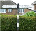
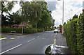
Old Direction Sign - Signpost by Deyes Lane, Maghull parish
Bishop finial - 2 arms; by the UC road, in parish of Maghull (Sefton District), Deyes Lane, Maghull, junction with Foxhouse Lane, on pavement, against hedge and low brick wall.
To be surveyed
Milestone Society National ID: LA_SD3802
Image: © Milestone Society
Taken: Unknown
0.24 miles