IMAGES TAKEN NEAR TO
Moorhey Road, LIVERPOOL, L31 5LP
Introduction
This page details the photographs taken nearby to Moorhey Road, L31 5LP by members of the Geograph project.
The Geograph project started in 2005 with the aim of publishing, organising and preserving representative images for every square kilometre of Great Britain, Ireland and the Isle of Man.

There are currently over 7.5m images from over14,400 individuals and you can help contribute to the project by visiting https://www.geograph.org.uk
Image Map
Images are licensed for reuse under creativecommons.org/licenses/by-sa/2.0
Notes
- Clicking on the map will re-center to the selected point.
- The higher the marker number, the further away the image location is from the centre of the postcode.
Image Listing (45 Images Found)
Images are licensed for reuse under creativecommons.org/licenses/by-sa/2.0
Image
Details
Distance
1
Fields and rails, Maghull
A train on the Liverpool-Ormskirk line approaching Maghull station.
Image: © Mike Pennington
Taken: 11 Jul 2007
0.06 miles
2
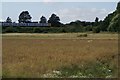
Pimbley playing fields, Maghull
Apparently named after the farmer who owned the land before the area was built on.
Image: © Mike Pennington
Taken: 11 Jul 2007
0.08 miles
3
Wartime relic on leeds liverpool canal near Maghull
Image: © Gary Rogers
Taken: 7 Aug 2014
0.10 miles
4
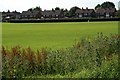
Hudson Road, Maghull
Built sometime in the 1950s as Maghull began its progression from sleepy village to commuter town. The photographer lived here briefly in the mid-1960s.
Image: © Mike Pennington
Taken: 23 Jul 2009
0.10 miles
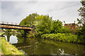
5
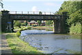
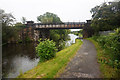
Railway bridge over the canal at Maghull
The bridge carries the Liverpool-Ormskirk electrified line over the Leeds-Liverpool canal.
Image: © Mike Pennington
Taken: 11 Jul 2007
0.11 miles
6
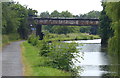
Maghull Railway Bridge No 11a
Crossing the Leeds and Liverpool Canal near Maghull.
Image: © Mat Fascione
Taken: 26 Jun 2016
0.11 miles
8
![Railway bridge [no 11A], Maghull](https://s3.geograph.org.uk/geophotos/06/90/00/6900055_84e60028_120x120.jpg)
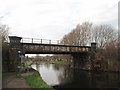
Railway bridge [no 11A], Maghull
Crossing the Leeds & Liverpool canal.
Image: © Christine Johnstone
Taken: 27 May 2021
0.12 miles
10
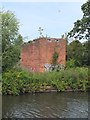
WWII Lancashire: Leeds & Liverpool Canal: Maghull (1)
-
Pillbox: DoB ID: S0011743
Soon after the outbreak of the Second World War, lines of defence or Stop-Lines were created all over the country in anticipation of invasion by the enemy forces of Nazi Germany. In Lancashire the Leeds & Liverpool Canal was chosen as one such line of defence in the event of a landing by German forces at Formby. This is the beginning of a series of linked photos taken along the Leeds & Liverpool Canal of some of the more interesting defensive structures that are still in existence today.
Two-storey block houses are not uncommon on the canal, this example at Melling on the outskirts of Maghull overlooks the canal and bridge. A brick built structure, the top four courses above the embrasures along with the 6in concrete roof are now missing. Access to the top storey would have been by 'Jacob's Ladder', with the lower floor used for storage.
Update 2021: I've received information that this pillbox has now been demolished.
Image
Image: © Mike Searle
Taken: 17 May 2018
0.14 miles