IMAGES TAKEN NEAR TO
Moorland Road, LIVERPOOL, L31 5JW
Introduction
This page details the photographs taken nearby to Moorland Road, L31 5JW by members of the Geograph project.
The Geograph project started in 2005 with the aim of publishing, organising and preserving representative images for every square kilometre of Great Britain, Ireland and the Isle of Man.

There are currently over 7.5m images from over14,400 individuals and you can help contribute to the project by visiting https://www.geograph.org.uk
Image Map
Images are licensed for reuse under creativecommons.org/licenses/by-sa/2.0
Notes
- Clicking on the map will re-center to the selected point.
- The higher the marker number, the further away the image location is from the centre of the postcode.
Image Listing (11 Images Found)
Images are licensed for reuse under creativecommons.org/licenses/by-sa/2.0
Image
Details
Distance
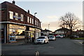
1
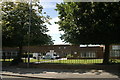
Hudson Primary School, Maghull
Attended by the photographer in the late 1960s and early 1970s; the trees have grown and the playground has more in it, but little else has changed.
Image: © Mike Pennington
Taken: 23 Jul 2009
0.08 miles
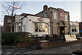
4
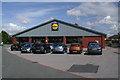
Lidl supermarket, Maghull
Built on the site of the former Albany cinema.
Image: © Mike Pennington
Taken: 23 Jul 2009
0.18 miles
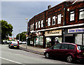
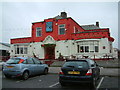
7
Northway chippy, Maghull
There has been a chippy with the same name here since the at least the 1970s. Next door used to be a newsagent.
Image: © Mike Pennington
Taken: 23 Jul 2009
0.21 miles
9
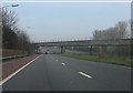
M58 motorway - Liverpool-Ormskirk railway bridge
Image: © Peter Whatley
Taken: 23 Mar 2012
0.22 miles
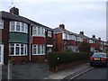
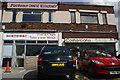
10
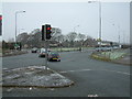
Northway
Taken from Dover Road, Liverpool Road opposite Northway left & right
Image: © Peter Hodge
Taken: 29 Dec 2005
0.23 miles