IMAGES TAKEN NEAR TO
The Croft, LIVERPOOL, L31 4JY
Introduction
This page details the photographs taken nearby to The Croft, L31 4JY by members of the Geograph project.
The Geograph project started in 2005 with the aim of publishing, organising and preserving representative images for every square kilometre of Great Britain, Ireland and the Isle of Man.

There are currently over 7.5m images from over14,400 individuals and you can help contribute to the project by visiting https://www.geograph.org.uk
Image Map
Images are licensed for reuse under creativecommons.org/licenses/by-sa/2.0
Notes
- Clicking on the map will re-center to the selected point.
- The higher the marker number, the further away the image location is from the centre of the postcode.
Image Listing (43 Images Found)
Images are licensed for reuse under creativecommons.org/licenses/by-sa/2.0
Image
Details
Distance
1
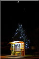
Bus stop at night, Southport Road, Lydiate
Christmas decorations are still on the tree on the green behind the bus stop, and a crescent Moon and Venus are in the sky.
Image: © Mike Pennington
Taken: 2 Jan 2017
0.04 miles
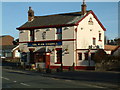
3
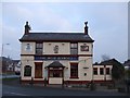
The Weld Blundell public house, Lydiate
Image: © Mike Pennington
Taken: 22 Dec 2015
0.07 miles
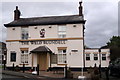
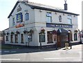
6
The Weld Blundell Arms, Lydiate
On Southport Road (A5147).
Image: © JThomas
Taken: 28 Apr 2019
0.07 miles
9
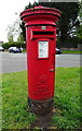
Elizabeth II postbox on Southport Road, Lydiate
Postbox No. L31 591.
Image: © JThomas
Taken: 28 Apr 2019
0.08 miles
10
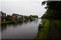
Leeds & Liverpool Canal
At bridge 17, Dicconson's Bridge.
Image: © Ian S
Taken: 11 Jun 2019
0.09 miles