IMAGES TAKEN NEAR TO
Northway, LIVERPOOL, L31 4EJ
Introduction
This page details the photographs taken nearby to Northway, L31 4EJ by members of the Geograph project.
The Geograph project started in 2005 with the aim of publishing, organising and preserving representative images for every square kilometre of Great Britain, Ireland and the Isle of Man.

There are currently over 7.5m images from over14,400 individuals and you can help contribute to the project by visiting https://www.geograph.org.uk
Image Map
Images are licensed for reuse under creativecommons.org/licenses/by-sa/2.0
Notes
- Clicking on the map will re-center to the selected point.
- The higher the marker number, the further away the image location is from the centre of the postcode.
Image Listing (7 Images Found)
Images are licensed for reuse under creativecommons.org/licenses/by-sa/2.0
Image
Details
Distance
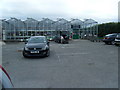
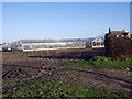
2
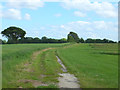
Path between Old Lane and Millbank Lane
Image: © Gary Rogers
Taken: 11 Jun 2017
0.08 miles
4
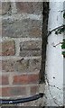
Ordnance Survey Cut Mark
This can be found on the roadside wall of a barn at Highway Farm, Aughton Chase.
For more detail see : http://www.bench-marks.org.uk/bm60241
Image: © Peter Wood
Taken: 5 Sep 2014
0.20 miles
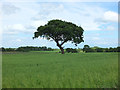
6
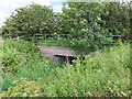
Bridge where Sudell Brook passes under the A59
Sudell Brook forms the county boundary here between West Lancashire and Sefton
Image: © Gary Rogers
Taken: 11 Jun 2017
0.23 miles
7
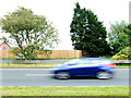
Between Sefton and West Lancashire
There is short stretch (~30m) of the A59 at Aughton Chase between the signs for West Lancashire and Sefton Borough where it would seem you are in no man's land. The boundary line is actually where Sudell Brook runs beneath the A59, between the two borough signs.
Image: © Gary Rogers
Taken: 11 Jun 2017
0.25 miles