IMAGES TAKEN NEAR TO
Liverpool Road, LIVERPOOL, L31 2LS
Introduction
This page details the photographs taken nearby to Liverpool Road, L31 2LS by members of the Geograph project.
The Geograph project started in 2005 with the aim of publishing, organising and preserving representative images for every square kilometre of Great Britain, Ireland and the Isle of Man.

There are currently over 7.5m images from over14,400 individuals and you can help contribute to the project by visiting https://www.geograph.org.uk
Image Map
Images are licensed for reuse under creativecommons.org/licenses/by-sa/2.0
Notes
- Clicking on the map will re-center to the selected point.
- The higher the marker number, the further away the image location is from the centre of the postcode.
Image Listing (32 Images Found)
Images are licensed for reuse under creativecommons.org/licenses/by-sa/2.0
Image
Details
Distance
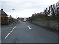
1
Junction of Nedens Lane and Liverpool Road, Lydiate
Image: © Gary Rogers
Taken: 11 Jun 2017
0.01 miles
3
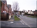
Maghull boundary post on Southport Road
Image: © Raymond Knapman
Taken: 13 Feb 2009
0.09 miles
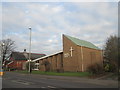
4
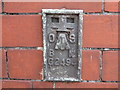
Ordnance Survey Flush Bracket G2494
This can be found on the wall of The Methodist Church.
For more detail see : http://www.bench-marks.org.uk/bm14724
Image: © Peter Wood
Taken: 3 May 2014
0.10 miles
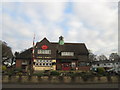
6
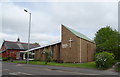
Maghull Methodist Church
On Liverpool Road North, Maghull.
Image: © JThomas
Taken: 28 Apr 2019
0.12 miles