IMAGES TAKEN NEAR TO
Rock Lane, LIVERPOOL, L31 1EN
Introduction
This page details the photographs taken nearby to Rock Lane, L31 1EN by members of the Geograph project.
The Geograph project started in 2005 with the aim of publishing, organising and preserving representative images for every square kilometre of Great Britain, Ireland and the Isle of Man.

There are currently over 7.5m images from over14,400 individuals and you can help contribute to the project by visiting https://www.geograph.org.uk
Image Map
Images are licensed for reuse under creativecommons.org/licenses/by-sa/2.0
Notes
- Clicking on the map will re-center to the selected point.
- The higher the marker number, the further away the image location is from the centre of the postcode.
Image Listing (61 Images Found)
Images are licensed for reuse under creativecommons.org/licenses/by-sa/2.0
Image
Details
Distance
1
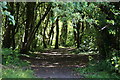
Path in Melling Delph
The delph, a former sandstone quarry, is now a public amenity managed for wildlife.
Image: © Mike Pennington
Taken: 5 Jul 2016
0.02 miles
2

Comma butterfly (Polygonia c-album), Melling Delph
Now quite common in this area, but a recent colonist in the last quarter of a century or so.
Image: © Mike Pennington
Taken: 5 Jul 2016
0.02 miles
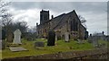
3
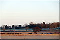
Melling Rock
Taken from the junction of Brewery Lane and Spencer's Lane.
Image: © Mike Pennington
Taken: 2 Jan 2017
0.02 miles
4
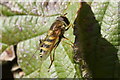
A Syrphus hoverfly, Melling Delph
Syrphus hoverflies are common migrants. Three species occur in Britain regularly, but they are not often separable in the field.
Image: © Mike Pennington
Taken: 5 Jul 2016
0.03 miles
6
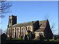
Church of St Thomas and the Holy Rood, Melling
Church of St Thomas and the Holy Rood, Melling was founded before 1603.
Image: © Sue Adair
Taken: 14 Jan 2006
0.03 miles

9
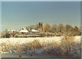
Melling Rock from the canal
The church of St Thomas' sits on top of the Rock, a small sandstone outcrop which is one of the highest points in the area.
Image: © Tom Pennington
Taken: Unknown
0.03 miles
10
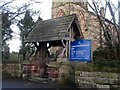
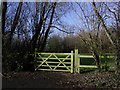
Lych Gate, St.Thomas' Church, Melling
The Lych Gate is also the village War Memorial
Image: © Tom Pennington
Taken: Unknown
0.03 miles