IMAGES TAKEN NEAR TO
Tithebarn Lane, LIVERPOOL, L31 1EG
Introduction
This page details the photographs taken nearby to Tithebarn Lane, L31 1EG by members of the Geograph project.
The Geograph project started in 2005 with the aim of publishing, organising and preserving representative images for every square kilometre of Great Britain, Ireland and the Isle of Man.

There are currently over 7.5m images from over14,400 individuals and you can help contribute to the project by visiting https://www.geograph.org.uk
Image Map
Images are licensed for reuse under creativecommons.org/licenses/by-sa/2.0
Notes
- Clicking on the map will re-center to the selected point.
- The higher the marker number, the further away the image location is from the centre of the postcode.
Image Listing (33 Images Found)
Images are licensed for reuse under creativecommons.org/licenses/by-sa/2.0
Image
Details
Distance
4
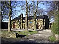
Tithebarn, Melling
The old tithebarn serves as the church hall. It can be hired for functions and is home to the Tithebarn Arts Association who organise concerts featuring mainly local musicians and performers.
Image: © Tom Pennington
Taken: 2 Feb 2007
0.06 miles
5
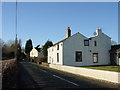
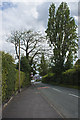
Tithebarn Lane, Melling
Looking west along Tithebarn Lane, Melling towards the old schoolhouse
Image: © Sue Adair
Taken: 14 Jan 2006
0.09 miles

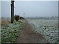
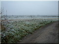
7

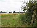
Field of barley and footpath to Waddicar
A field of ripe barley adjacent to the footpath from Melling Rocks to Waddicar Lane.
Image: © Sue Adair
Taken: 24 Jun 2014
0.19 miles
10
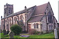
St Thomas, Melling
1835. Architect J W Casson. Replaced Church of the Holy Rood, c. 1195, demolished 1834.
Image: © S Parish
Taken: 12 Jan 2006
0.23 miles