IMAGES TAKEN NEAR TO
School Lane, LIVERPOOL, L31 1BE
Introduction
This page details the photographs taken nearby to School Lane, L31 1BE by members of the Geograph project.
The Geograph project started in 2005 with the aim of publishing, organising and preserving representative images for every square kilometre of Great Britain, Ireland and the Isle of Man.

There are currently over 7.5m images from over14,400 individuals and you can help contribute to the project by visiting https://www.geograph.org.uk
Image Map
Images are licensed for reuse under creativecommons.org/licenses/by-sa/2.0
Notes
- Clicking on the map will re-center to the selected point.
- The higher the marker number, the further away the image location is from the centre of the postcode.
Image Listing (24 Images Found)
Images are licensed for reuse under creativecommons.org/licenses/by-sa/2.0
Image
Details
Distance
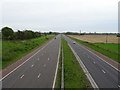
1
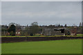
Bradley's Farm, Moss Side, Maghull
From the bridge over the M58.
Image: © Mike Pennington
Taken: 6 Apr 2014
0.01 miles
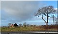
5
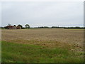
Farmland near Bradley's Farm
Off School Lane.
Image: © JThomas
Taken: 28 Apr 2019
0.10 miles
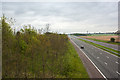
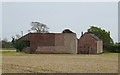
7
The M58 Motorway
Looking south west from the bridge at Junction 1.
Image: © JThomas
Taken: 28 Apr 2019
0.11 miles
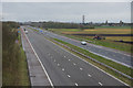
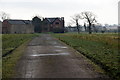
9
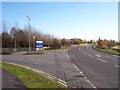
Entrance to Ashworth Hospital off School Lane
M58 Junction 1 slip roads in distance
Image: © Raymond Knapman
Taken: 10 Nov 2010
0.13 miles
10
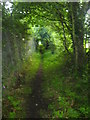
Secluded footpath
A footpath leading to the park in Maghull
Image: © Emma White
Taken: 1 Aug 2012
0.14 miles