IMAGES TAKEN NEAR TO
Prescot Road, LIVERPOOL, L31 1AW
Introduction
This page details the photographs taken nearby to Prescot Road, L31 1AW by members of the Geograph project.
The Geograph project started in 2005 with the aim of publishing, organising and preserving representative images for every square kilometre of Great Britain, Ireland and the Isle of Man.

There are currently over 7.5m images from over14,400 individuals and you can help contribute to the project by visiting https://www.geograph.org.uk
Image Map
Images are licensed for reuse under creativecommons.org/licenses/by-sa/2.0
Notes
- Clicking on the map will re-center to the selected point.
- The higher the marker number, the further away the image location is from the centre of the postcode.
Image Listing (13 Images Found)
Images are licensed for reuse under creativecommons.org/licenses/by-sa/2.0
Image
Details
Distance
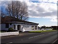
1
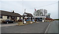
Service station on Prescot Road (B5197), Cunscough Bridge West
Image: © JThomas
Taken: 28 Apr 2019
0.04 miles
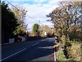
2
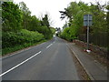
The B5197 road at Cunscough Bridge
Looking north-westward.
Image: © Peter Wood
Taken: 31 Aug 2014
0.04 miles
3
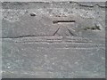
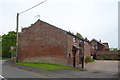
Ordnance Survey Cut Mark
This can be found on the wall of Cunscough Bridge West.
For more detail see : http://www.bench-marks.org.uk/bm57918
Image: © Peter Wood
Taken: 31 Aug 2014
0.04 miles
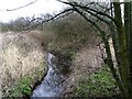
4
Prescot Road crosses Cunscough Brook
The bridge over the brook is indicated by stone parapets
Image: © Raymond Knapman
Taken: 10 Nov 2010
0.04 miles
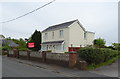
6
The Chesterfield restaurant on Prescot Road
Image: © Raymond Knapman
Taken: 10 Nov 2010
0.06 miles
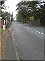
7
Prescot Road (B5197), Cunscough Bridge West
Looking south east.
Image: © JThomas
Taken: 28 Apr 2019
0.08 miles