IMAGES TAKEN NEAR TO
Giddygate Lane, LIVERPOOL, L31 1AQ
Introduction
This page details the photographs taken nearby to Giddygate Lane, L31 1AQ by members of the Geograph project.
The Geograph project started in 2005 with the aim of publishing, organising and preserving representative images for every square kilometre of Great Britain, Ireland and the Isle of Man.

There are currently over 7.5m images from over14,400 individuals and you can help contribute to the project by visiting https://www.geograph.org.uk
Image Map
Images are licensed for reuse under creativecommons.org/licenses/by-sa/2.0
Notes
- Clicking on the map will re-center to the selected point.
- The higher the marker number, the further away the image location is from the centre of the postcode.
Image Listing (5 Images Found)
Images are licensed for reuse under creativecommons.org/licenses/by-sa/2.0
Image
Details
Distance
2
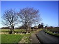
Giddygate Lane and Moorfield House, Melling
Image: © Tom Pennington
Taken: 2 Feb 2007
0.10 miles
3

Crops growing in Melling
Crops growing in a field near Melling, Liverpool
Image: © Emma White
Taken: 1 Aug 2012
0.18 miles
4

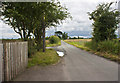
Giddygate Lane joins Leatherbarrows Lane
Farm buildings and cottages shown on corner of junction
Image: © Raymond Knapman
Taken: 15 Nov 2010
0.18 miles
