IMAGES TAKEN NEAR TO
Prescot Road, LIVERPOOL, L31 1AP
Introduction
This page details the photographs taken nearby to Prescot Road, L31 1AP by members of the Geograph project.
The Geograph project started in 2005 with the aim of publishing, organising and preserving representative images for every square kilometre of Great Britain, Ireland and the Isle of Man.

There are currently over 7.5m images from over14,400 individuals and you can help contribute to the project by visiting https://www.geograph.org.uk
Image Map
Images are licensed for reuse under creativecommons.org/licenses/by-sa/2.0
Notes
- Clicking on the map will re-center to the selected point.
- The higher the marker number, the further away the image location is from the centre of the postcode.
Image Listing (12 Images Found)
Images are licensed for reuse under creativecommons.org/licenses/by-sa/2.0
Image
Details
Distance
1
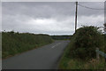
Angers Lane, Melling
At the junction with Prescot Road.
Image: © Mike Pennington
Taken: 13 Oct 2013
0.03 miles
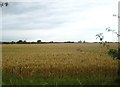
5
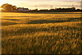
Barley field at sunset, Melling
Looking towards Glover's Farm.
Image: © Mike Pennington
Taken: 5 Jul 2015
0.13 miles
6
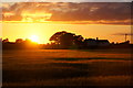
Sunset over a field of barley, Melling
Image: © Mike Pennington
Taken: 5 Jul 2015
0.13 miles
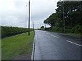
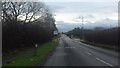
7

Waddicar Lane joins Prescot Road near Melling House
Image: © Raymond Knapman
Taken: 15 Nov 2010
0.16 miles
8

A field near Melling
Just off the side of the lane leading to Melling
Image: © Emma White
Taken: 1 Aug 2012
0.17 miles
10

Fields at Melling
What a difference a day makes- 23 hours after this view from the same spot: Image
Image: © Mike Pennington
Taken: 6 Jul 2015
0.22 miles