IMAGES TAKEN NEAR TO
Kenyons Lane, LIVERPOOL, L31 0BF
Introduction
This page details the photographs taken nearby to Kenyons Lane, L31 0BF by members of the Geograph project.
The Geograph project started in 2005 with the aim of publishing, organising and preserving representative images for every square kilometre of Great Britain, Ireland and the Isle of Man.

There are currently over 7.5m images from over14,400 individuals and you can help contribute to the project by visiting https://www.geograph.org.uk
Image Map
Images are licensed for reuse under creativecommons.org/licenses/by-sa/2.0
Notes
- Clicking on the map will re-center to the selected point.
- The higher the marker number, the further away the image location is from the centre of the postcode.
Image Listing (9 Images Found)
Images are licensed for reuse under creativecommons.org/licenses/by-sa/2.0
Image
Details
Distance
1
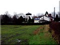
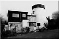
Lydiate Windmill.
This windmill is now a private residence.
Image: © Norman Caesar
Taken: 11 Dec 2011
0.14 miles
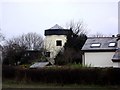
3
Lydiate Windmill
Forest's or Foster's Mill, Lydiate, built in 1768, long derelict and converted into a house in the 1960s.
Image: © Gareth Hughes
Taken: Unknown
0.18 miles
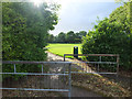
4
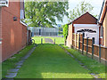
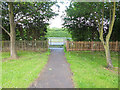
Cut-Through from Ridgeway Drive to Ridgeway Park, Lydiate
Image: © Gary Rogers
Taken: 11 Jun 2017
0.19 miles
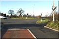
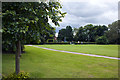
7
Cut-Through from Ridgeway Drive to Northway, Lydiate
Image: © Gary Rogers
Taken: 11 Jun 2017
0.23 miles