IMAGES TAKEN NEAR TO
Bridle Road, BOOTLE, L30 4YD
Introduction
This page details the photographs taken nearby to Bridle Road, L30 4YD by members of the Geograph project.
The Geograph project started in 2005 with the aim of publishing, organising and preserving representative images for every square kilometre of Great Britain, Ireland and the Isle of Man.

There are currently over 7.5m images from over14,400 individuals and you can help contribute to the project by visiting https://www.geograph.org.uk
Image Map
Images are licensed for reuse under creativecommons.org/licenses/by-sa/2.0
Notes
- Clicking on the map will re-center to the selected point.
- The higher the marker number, the further away the image location is from the centre of the postcode.
Image Listing (5 Images Found)
Images are licensed for reuse under creativecommons.org/licenses/by-sa/2.0
Image
Details
Distance
1
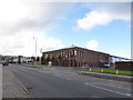
Merseyside Fire and Rescue headquarters
Bridle Road, Orrell.
Image: © Stephen Craven
Taken: 4 Nov 2017
0.01 miles
2

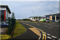
Essex House, Bridle Road, Bootle
Currently to let.
Image: © Stephen Craven
Taken: 4 Nov 2017
0.06 miles
5

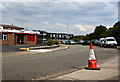
Eastbound freight on North Mersey line passing site of Ford Station and Aintree Sorting Sidings
View westwards near Sefton Junction, towards North Mersey Goods, Gladstone Dock and Liverpool Exchange via Linacre Road; ex-Lancashire & Yorkshire line. Ford station (closed 2/4/51) was this side of the A5038 bridge in the distance; Aintree SS are across on the south side of the line. The locomotive on the Class F freight is ex-War Department 2-8-0 No. 90557: note that it is fitted with a snow-plough - in mid-June.
[I thank Phil Prosser for his corrections].
Image: © Ben Brooksbank
Taken: 12 Jun 1959
0.24 miles