IMAGES TAKEN NEAR TO
Sarahs Croft, BOOTLE, L30 3SS
Introduction
This page details the photographs taken nearby to Sarahs Croft, L30 3SS by members of the Geograph project.
The Geograph project started in 2005 with the aim of publishing, organising and preserving representative images for every square kilometre of Great Britain, Ireland and the Isle of Man.

There are currently over 7.5m images from over14,400 individuals and you can help contribute to the project by visiting https://www.geograph.org.uk
Image Map
Images are licensed for reuse under creativecommons.org/licenses/by-sa/2.0
Notes
- Clicking on the map will re-center to the selected point.
- The higher the marker number, the further away the image location is from the centre of the postcode.
Image Listing (19 Images Found)
Images are licensed for reuse under creativecommons.org/licenses/by-sa/2.0
Image
Details
Distance
4
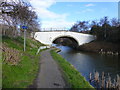
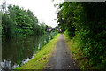
Swift's Bridge on the Leeds Liverpool Canal at Netherton
Image: © Raymond Knapman
Taken: 21 Feb 2014
0.19 miles
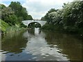
5
Swift's Lane Bridge
Swift's Lane Bridge is Bridge 5 on the Leeds-Liverpool Canal.
Image: © Rude Health
Taken: 12 Aug 2015
0.19 miles
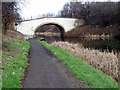
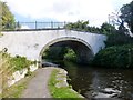
6
Swift's Bridge [no 5], from the north-east
Carrying Swifts Lane over the Leeds & Liverpool Canal. Now with a separate footbridge.
Image: © Christine Johnstone
Taken: 25 May 2021
0.19 miles
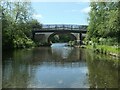
7
Swift's Bridge [no 5] from the south-west
Carrying Swifts Lane over the Leeds & Liverpool canal.
Image: © Christine Johnstone
Taken: 27 May 2021
0.19 miles
8
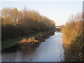
Leeds-Liverpool Canal from Swift's Lane Bridge
Image: © Sue Adair
Taken: 20 Nov 2009
0.19 miles
9
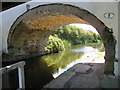
Swift's Bridge #5 over the Leeds-Liverpool Canal
The north east side of Swift's Bridge, which carries Swift's Lane over the Leeds-Liverpool Canal. There is an Ordnance Survey bench mark on the stone next to the towpath - Image This weathered bench mark first appears on Swift's bridge in 1893 and disappears from the maps after 1939. The bridge was originally Moss Side Bridge and carried Moss Lane over the Leeds-Liverpool canal. Before 1893 the bridge name changed to Swift's Bridge, and eventually the lane name was changed to Swift's Lane after 1955.
Image: © John S Turner
Taken: 15 Aug 2017
0.19 miles