IMAGES TAKEN NEAR TO
Sarahs Croft, BOOTLE, L30 3RX
Introduction
This page details the photographs taken nearby to Sarahs Croft, L30 3RX by members of the Geograph project.
The Geograph project started in 2005 with the aim of publishing, organising and preserving representative images for every square kilometre of Great Britain, Ireland and the Isle of Man.

There are currently over 7.5m images from over14,400 individuals and you can help contribute to the project by visiting https://www.geograph.org.uk
Image Map
Images are licensed for reuse under creativecommons.org/licenses/by-sa/2.0
Notes
- Clicking on the map will re-center to the selected point.
- The higher the marker number, the further away the image location is from the centre of the postcode.
Image Listing (28 Images Found)
Images are licensed for reuse under creativecommons.org/licenses/by-sa/2.0
Image
Details
Distance
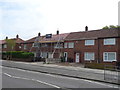
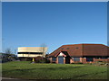
1
The Eden Vale public house, Netherton
On Glovers Lane.
Image: © JThomas
Taken: 28 Apr 2019
0.15 miles
3
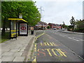
Bus stop and shelter on Glovers Lane
Looking east.
Image: © JThomas
Taken: 28 Apr 2019
0.16 miles
5
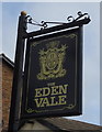
Sign for the Eden Vale public house, Netherton
Image: © JThomas
Taken: 28 Apr 2019
0.16 miles
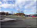
7
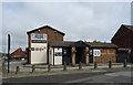
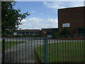
Glover's Lane Surgery, Magdalen Square
Glover's Lane Surgery, Magdalen Square with The Feelgood Factory to the left.
Image: © Sue Adair
Taken: 25 Jan 2009
0.18 miles
9
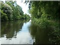
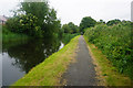
Leeds & Liverpool canal, between bridges 5A and 5
A boater's view.
Image: © Christine Johnstone
Taken: 25 May 2021
0.19 miles
10
Trans Pennine Trail sign on St Oswald's Lane
Doctors surgery in background
Image: © Raymond Knapman
Taken: 21 Feb 2014
0.19 miles