IMAGES TAKEN NEAR TO
Marina Crescent, BOOTLE, L30 1RR
Introduction
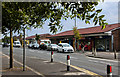
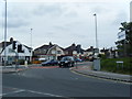
This page details the photographs taken nearby to Marina Crescent, L30 1RR by members of the Geograph project.
The Geograph project started in 2005 with the aim of publishing, organising and preserving representative images for every square kilometre of Great Britain, Ireland and the Isle of Man.

There are currently over 7.5m images from over14,400 individuals and you can help contribute to the project by visiting https://www.geograph.org.uk
Image Map
Images are licensed for reuse under creativecommons.org/licenses/by-sa/2.0
Notes
- Clicking on the map will re-center to the selected point.
- The higher the marker number, the further away the image location is from the centre of the postcode.
Image Listing (3 Images Found)
Images are licensed for reuse under creativecommons.org/licenses/by-sa/2.0
Image
Details
Distance
3
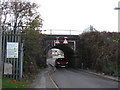
Low Bridge, Heysham Road
This railway bridge on Heysham Road is only usable by cars due to it being very low and narrow. It carries the Liverpool to Ormskirk line. It is a well used short-cut between Ormskirk Road and Dunnings Bridge Road.
Image: © Sue Adair
Taken: 3 Nov 2007
0.24 miles