IMAGES TAKEN NEAR TO
Stonyfield, BOOTLE, L30 0QZ
Introduction
This page details the photographs taken nearby to Stonyfield, L30 0QZ by members of the Geograph project.
The Geograph project started in 2005 with the aim of publishing, organising and preserving representative images for every square kilometre of Great Britain, Ireland and the Isle of Man.

There are currently over 7.5m images from over14,400 individuals and you can help contribute to the project by visiting https://www.geograph.org.uk
Image Map
Images are licensed for reuse under creativecommons.org/licenses/by-sa/2.0
Notes
- Clicking on the map will re-center to the selected point.
- The higher the marker number, the further away the image location is from the centre of the postcode.
Image Listing (21 Images Found)
Images are licensed for reuse under creativecommons.org/licenses/by-sa/2.0
Image
Details
Distance
1
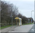
Bus Stop on the Northern Perimeter Road
Image: © Anthony Parkes
Taken: 28 Dec 2015
0.06 miles
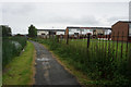
3
Netherton Lane
In the sixties this was the only road to Netherton from Thornton
Image: © Norman Caesar
Taken: 18 Jan 2014
0.13 miles
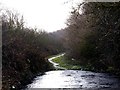
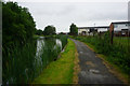
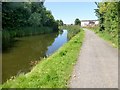
4
Towpath along the Leeds and Liverpool Canal
Image: © Mat Fascione
Taken: 26 Jun 2016
0.17 miles
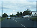
5
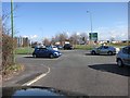
Road Junction A5207/B5422
This road junction sits en route from the end of the M57 & M58 to Altcar Ranges - familiar to many TA soldiers in the North West.
Image: © John Tustin
Taken: 28 Mar 2009
0.17 miles
9
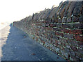
Brick Wall
This brick wall is approximately one kilometre long, giving the lane its name, Brickwall Lane
Image: © Norman Caesar
Taken: 14 Jan 2012
0.18 miles
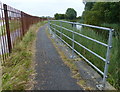
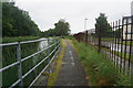
10
Towpath View
A view along the Leeds-Liverpool towpath towards some houses close to the local primary school.
Image: © Rude Health
Taken: 12 Aug 2015
0.18 miles