IMAGES TAKEN NEAR TO
Buckley Hill Lane, LIVERPOOL, L29 1YB
Introduction
This page details the photographs taken nearby to Buckley Hill Lane, L29 1YB by members of the Geograph project.
The Geograph project started in 2005 with the aim of publishing, organising and preserving representative images for every square kilometre of Great Britain, Ireland and the Isle of Man.

There are currently over 7.5m images from over14,400 individuals and you can help contribute to the project by visiting https://www.geograph.org.uk
Image Map
Images are licensed for reuse under creativecommons.org/licenses/by-sa/2.0
Notes
- Clicking on the map will re-center to the selected point.
- The higher the marker number, the further away the image location is from the centre of the postcode.
Image Listing (6 Images Found)
Images are licensed for reuse under creativecommons.org/licenses/by-sa/2.0
Image
Details
Distance
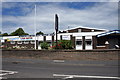
2
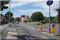
Fleetwood's Lane, Netherton
The red building at the end is a fire station.
Image: © Mike Pennington
Taken: 30 Jun 2015
0.13 miles
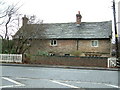
4
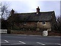
Sandstone cottage, Buckley Hill Lane
Image: © Tom Pennington
Taken: 13 Feb 2007
0.14 miles
5
Orchard Farm
Old building in an modern area. Next to a number of football pitches
Image: © Peter Hodge
Taken: 31 Dec 2005
0.15 miles
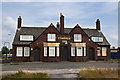
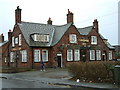
6
Netherton & Sefton British Legion, Fleetwood's Lane, Netherton
Image: © Mike Pennington
Taken: 30 Jun 2015
0.17 miles