IMAGES TAKEN NEAR TO
Hare Croft, LIVERPOOL, L28 8AE
Introduction
This page details the photographs taken nearby to Hare Croft, L28 8AE by members of the Geograph project.
The Geograph project started in 2005 with the aim of publishing, organising and preserving representative images for every square kilometre of Great Britain, Ireland and the Isle of Man.

There are currently over 7.5m images from over14,400 individuals and you can help contribute to the project by visiting https://www.geograph.org.uk
Image Map
Images are licensed for reuse under creativecommons.org/licenses/by-sa/2.0
Notes
- Clicking on the map will re-center to the selected point.
- The higher the marker number, the further away the image location is from the centre of the postcode.
Image Listing (9 Images Found)
Images are licensed for reuse under creativecommons.org/licenses/by-sa/2.0
Image
Details
Distance
1
River Alt at Stockbridge Village
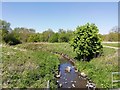
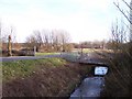
The River Alt rises in Huyton at the Hag Plantation and flows under Stockbridge Village through Croxteth Park, West Derby, Aintree and Sefton and out to the River Mersey at Hightown. Here it is emerging from beneath Stockbridge Village at Mab Lane Community Woodland with the ubiquitous shopping trolley.
Image: © Sue Adair
Taken: 24 Apr 2020
0.07 miles
5
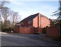
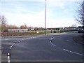
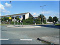
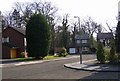
Private housing estate off Deysbrook Lane
Image: © Raymond Knapman
Taken: 8 Feb 2011
0.18 miles
6
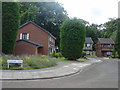
Brookside Close
Yes, this is the infamous Brookside Close of the Channel 4 soap, a cul-de-sac of real houses, now sadly up for sale due to the sad demise of the programme. Situated off Deysbrook Lane in what was once the Croxteth Hall estate.
Image: © Sue Adair
Taken: 14 Aug 2005
0.18 miles
8
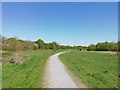
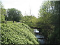
Mab Lane Community Woodland
The Mab Lane Community Woodland was planted on an unloved former playing field between Mab lane and Deysbrook Lane and was created as part of Liverpool's capital of culture year in 2008. This woodland has provided a green space for the local community and forms part of the larger Mersey Forest.
Image: © Sue Adair
Taken: 24 Apr 2020
0.21 miles
9
Brookside
This is what remains of Brookside Close that was the featured location of Channel 4's soap Brookside
Image: © Mr M Evison
Taken: 1 Apr 2007
0.23 miles