IMAGES TAKEN NEAR TO
Southbrook Road, LIVERPOOL, L27 1XX
Introduction
This page details the photographs taken nearby to Southbrook Road, L27 1XX by members of the Geograph project.
The Geograph project started in 2005 with the aim of publishing, organising and preserving representative images for every square kilometre of Great Britain, Ireland and the Isle of Man.

There are currently over 7.5m images from over14,400 individuals and you can help contribute to the project by visiting https://www.geograph.org.uk
Image Map
Images are licensed for reuse under creativecommons.org/licenses/by-sa/2.0
Notes
- Clicking on the map will re-center to the selected point.
- The higher the marker number, the further away the image location is from the centre of the postcode.
Image Listing (6 Images Found)
Images are licensed for reuse under creativecommons.org/licenses/by-sa/2.0
Image
Details
Distance
2
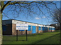
Hope School, Netherley
Hope School, Netherley, caters for boys between the ages of 7 and 14 who have severe social, emotional and behavioural problems.
Image: © Sue Adair
Taken: 7 Feb 2009
0.09 miles
3
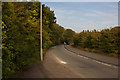
An avenue of trees at the side of Naylor's Road
Image: © Ian Greig
Taken: 27 Sep 2013
0.15 miles
4
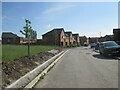
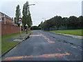
New houses on Galium Drive
Just the road to be adopted and the area to the left to be cleared and landscaped. turn left to exit the estate
Image: © Martin Dawes
Taken: 31 May 2021
0.22 miles
5
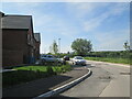
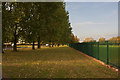
Galium Drive houses overlooking countryside
A new estate of private houses, still not complete as the road has not been fully surfaced, manholes standing proud
Image: © Martin Dawes
Taken: 31 May 2021
0.22 miles