IMAGES TAKEN NEAR TO
LIVERPOOL, L26 9YX
Introduction
This page details the photographs taken nearby to L26 9YX by members of the Geograph project.
The Geograph project started in 2005 with the aim of publishing, organising and preserving representative images for every square kilometre of Great Britain, Ireland and the Isle of Man.

There are currently over 7.5m images from over14,400 individuals and you can help contribute to the project by visiting https://www.geograph.org.uk
Image Map
Images are licensed for reuse under creativecommons.org/licenses/by-sa/2.0
Notes
- Clicking on the map will re-center to the selected point.
- The higher the marker number, the further away the image location is from the centre of the postcode.
Image Listing (35 Images Found)
Images are licensed for reuse under creativecommons.org/licenses/by-sa/2.0
Image
Details
Distance
1
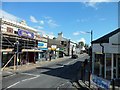
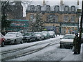
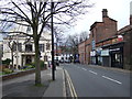
Acrefield Road, Woolton
The main street in the village of Woolton.
Image: © Stephen Sweeney
Taken: 21 Jun 2011
0.03 miles
2
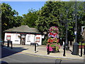
Woolton Village
Woolton today is a most desirable district to reside, the area being surrounded by the parklands of Calderstones, Beechley, Allerton Tower, Woolton Wood, Black Wood, Clarke Gardens, Eric Hardy Nature Reserve, Camp Hill, Childwall Woods, Halewood Triangle Country Park, Reynolds Park, and the golf courses of Woolton, Netherley and Allerton. The village centre boasts some of the finest restaurants and pubs (some of the latter with strict dress code) you would expect to find in a city centre and all within a few minutes walk of each other.
Image: © Sue Adair
Taken: 2 Sep 2005
0.06 miles
3
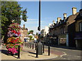
Woolton Village
Looking north up Woolton Street from Allerton Road. The name Woolton - Uluetune in the Domesday Book - derives from Wulfa's tun (tun: village farm, homestead), which is Anglo Saxon in origin.
Image: © Sue Adair
Taken: 2 Sep 2005
0.06 miles
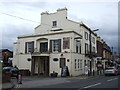
4
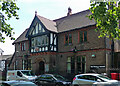
Club, Allerton Road, Liverpool
Woolton Village Club to be precise, built 1885, and still going.
Image: © Stephen Richards
Taken: 16 Aug 2016
0.06 miles
6
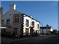
The Coffee House, Woolton
The Coffee House on Woolton Street, Woolton, bears the date 1641 at the side of the building. The white building in the background is the Salisbury Farm Dairy which is also a listed building.
Image: © Sue Adair
Taken: 14 Feb 2007
0.07 miles
8
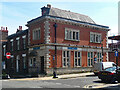
29 Allerton Road, Liverpool
Built as a branch of the Bank of Liverpool in 1901-02 by Willink & Thicknesse. "Quiter than most" (e.g. compare with Image]).
At the time it was still a branch of Barclays, but unsurprisingly it has since closed.
Image: © Stephen Richards
Taken: 16 Aug 2016
0.08 miles
10
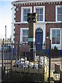
Woolton Cross
Located at the junction of Woolton Street with High Street, Woolton Cross was erected c.1350. Damaged at an unknown date, it was restored in 1913 when Woolton was incorporated into Liverpool.
Image: © Sue Adair
Taken: 1 Mar 2009
0.09 miles