IMAGES TAKEN NEAR TO
Honeysuckle Close, LIVERPOOL, L26 7XP
Introduction
This page details the photographs taken nearby to Honeysuckle Close, L26 7XP by members of the Geograph project.
The Geograph project started in 2005 with the aim of publishing, organising and preserving representative images for every square kilometre of Great Britain, Ireland and the Isle of Man.

There are currently over 7.5m images from over14,400 individuals and you can help contribute to the project by visiting https://www.geograph.org.uk
Image Map
Images are licensed for reuse under creativecommons.org/licenses/by-sa/2.0
Notes
- Clicking on the map will re-center to the selected point.
- The higher the marker number, the further away the image location is from the centre of the postcode.
Image Listing (10 Images Found)
Images are licensed for reuse under creativecommons.org/licenses/by-sa/2.0
Image
Details
Distance
1
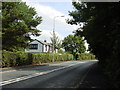
Lydiate Lane approaching Gerrard's Lane, Halewood Green
Image: © Sue Adair
Taken: 30 Aug 2005
0.05 miles
2
Clover Avenue
Part of a large new housing development on the edge of the Liverpool conurbation.
Image: © Bill Boaden
Taken: 24 Apr 2019
0.11 miles
3
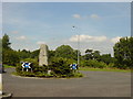
Roundabout, Church Road, Halewood Green
This roundabout at the junction of Okell Drive with Church Road, Halewood Green has a large slab of rock at the centre. It was unearthed during the building of the nearby housing estate and makes an interesting feature. It does not appear to be local as the bedrock is sandstone in the area.
Image: © Sue Adair
Taken: 30 Aug 2005
0.15 miles
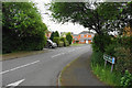
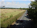
4

Lydiate Lane
An appearance of countryside, but there is a large new housing development behind the trees to the right.
Image: © Bill Boaden
Taken: 24 Apr 2019
0.20 miles
6
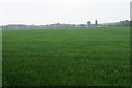
Wheat field near Halewood Farm
Looking south from Gerrard's Lane, on a day now producing light rain.
Image: © Bill Boaden
Taken: 24 Apr 2019
0.22 miles
7
Lydiate Lane from Transpennine trail
Looking north-east from the bridge over Lydiate Lane on the Transpennine trail towards Prescot in the distance
Image: © Sue Adair
Taken: 20 Aug 2005
0.24 miles
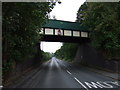
8

Bridge over Lydiate Lane
The Trans Pennine Trail is following the route of the former Liverpool Loop Line.
Image: © Bill Boaden
Taken: 24 Apr 2019
0.24 miles
9
Disused railway bridge over Lydiate Lane
Now used by the Trans Pennine Trail.
Image: © JThomas
Taken: 13 Sep 2014
0.24 miles
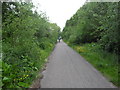
10

Lydiate Lane
The bridge carries the Liverpool Loopline which is a traffic free wildlife route running from Halewood to Aintree. It forms part of the Trans Pennine Trail. It makes good use of the line of a railway abandoned in 1964. http://www.sustrans.org.uk/ncn/map/route/liverpool-loopline
Image: © Ian Greig
Taken: 27 Jun 2014
0.25 miles