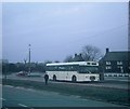
IMAGES TAKEN NEAR TO
Priorsfield Road, LIVERPOOL, L25 8TN

Introduction

This page details the photographs taken nearby to Priorsfield Road, L25 8TN by members of the Geograph project.

The Geograph project started in 2005 with the aim of publishing, organising and preserving representative images for every square kilometre of Great Britain, Ireland and the Isle of Man.

There are currently over 7.5m images from over14,400 individuals and you can help contribute to the project by visiting https://www.geograph.org.uk

Image Map


Images are licensed for reuse under creativecommons.org/licenses/by-sa/2.0
Notes
  • Clicking on the map will re-center to the selected point.
  • The higher the marker number, the further away the image location is from the centre of the postcode.

Image Listing (3 Images Found)

Images are licensed for reuse under creativecommons.org/licenses/by-sa/2.0
Image
Details
Distance
1
The English Rose pub
Image: © JThomas Taken: 13 Sep 2014
0.19 miles
2
Mackets Lane/Lydiate Lane roundabout
Image: © Colin Pyle Taken: 1 Jul 2010
0.19 miles
3
A single-decker bus at Woolton
Taken in March 1971, this photo shows a Leyland Panther single-decker bus in Kings Drive near Hunts Cross Avenue waiting to depart on route 4 to Liverpool city centre. It was one of 110 such vehicles delivered to Liverpool Corporation Transport in 1968/9 and has Metro-Cammell 47-seater bodywork. Although the vehicle is pictured with the city's coat of arms and the wording "City of Liverpool", it had been transferred with the transport undertaking to the Merseyside Passenger Transport Executive on the 1st December 1969.
Image: © David Hillas Taken: 27 Mar 1971
0.24 miles