IMAGES TAKEN NEAR TO
Roxborough Walk, LIVERPOOL, L25 5HN
Introduction
This page details the photographs taken nearby to Roxborough Walk, L25 5HN by members of the Geograph project.
The Geograph project started in 2005 with the aim of publishing, organising and preserving representative images for every square kilometre of Great Britain, Ireland and the Isle of Man.

There are currently over 7.5m images from over14,400 individuals and you can help contribute to the project by visiting https://www.geograph.org.uk
Image Map
Images are licensed for reuse under creativecommons.org/licenses/by-sa/2.0
Notes
- Clicking on the map will re-center to the selected point.
- The higher the marker number, the further away the image location is from the centre of the postcode.
Image Listing (7 Images Found)
Images are licensed for reuse under creativecommons.org/licenses/by-sa/2.0
Image
Details
Distance
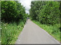

3

A footpath linking with the Liverpool Loopline
The Liverpool Loopline is a traffic free wildlife route running from Halewood to Aintree. It forms part of the Trans Pennine Trail. It makes good use of the line of a railway abandoned in 1964.
http://www.sustrans.org.uk/ncn/map/route/liverpool-loopline
Image: © Ian Greig
Taken: 27 Jun 2014
0.07 miles

5
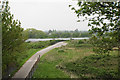
Track to sewage works
The sewage works are in the trees ahead. In front is a field of solar panels.
Image: © Bill Boaden
Taken: 24 Apr 2019
0.08 miles
6
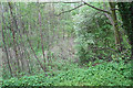
Woodland by the Trans Pennine Trail
Fairly thick woodland viewed from the embankment of the former Liverpool Loop Line.
Image: © Bill Boaden
Taken: 24 Apr 2019
0.13 miles