IMAGES TAKEN NEAR TO
Hartsbourne Avenue, LIVERPOOL, L25 2RX
Introduction
This page details the photographs taken nearby to Hartsbourne Avenue, L25 2RX by members of the Geograph project.
The Geograph project started in 2005 with the aim of publishing, organising and preserving representative images for every square kilometre of Great Britain, Ireland and the Isle of Man.

There are currently over 7.5m images from over14,400 individuals and you can help contribute to the project by visiting https://www.geograph.org.uk
Image Map (11 Images)


Getting Data...Please wait
Leaflet Map data © OpenStreetMap
Images are licensed for reuse under creativecommons.org/licenses/by-sa/2.0
Notes
- Clicking on the map will re-center to the selected point.
- The higher the marker number, the further away the image location is from the centre of the postcode.
Image Listing (11 Images Found)
Images are licensed for reuse under creativecommons.org/licenses/by-sa/2.0
Image
Details
Distance
1
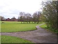
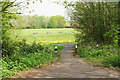
Parkland at Lyndene
The path in the foreground leads to the Trans Pennine Trail.
Image: © Raymond Knapman
Taken: 24 Apr 2012
0.09 miles
2
Grangemeadow Road, Gateacre
View down Grangemeadow Road and across Childwall Valley, with Huyton in the distance. The line of trees at the bottom of the road marks the Liverpool Loop Line cycle path, on the old Cheshire Lines Railway embankment.
Image: © Colin Pyle
Taken: 1 Jan 2003
0.13 miles
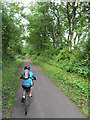
4
Informal path off the Trans Pennine Trail
There are plenty of official paths off the trail, but this is an extra one down the side of the embankment.
Image: © Bill Boaden
Taken: 24 Apr 2019
0.15 miles
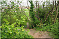
5
Path off the Trans Pennine Trail
The path goes onto one of the green spaces in the area, this one called Lyndene.
Image: © Bill Boaden
Taken: 24 Apr 2019
0.16 miles
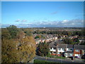
6
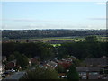
Childwall Valley from Gateacre Comprehensive School
Trees in the foreground mark the Liverpool Loop Line cycle path. Beyond the fields in the middle distance is the M62 motorway. Beyond Prescot church (with spire) can be seen Winter Hill, some 22 miles beyond.
Image: © Colin Pyle
Taken: 26 Sep 2007
0.19 miles
7
Colton Road joins Lyndene Road at Childwall
Trans Pennine Trail bridges Lyndene Road in background
Image: © Raymond Knapman
Taken: 24 Apr 2012
0.19 miles
8
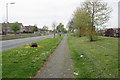
Childwall Valley Road
A broad road with large grass verges and housing on each side.
Image: © Bill Boaden
Taken: 24 Apr 2019
0.19 miles
9
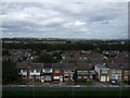
Childwall Valley
Childwall Valley seen from Gateacre Comprehensive School. The line of trees marks the Trans Pennine Trail beyond the houses. To the right beyond is Belle Vale Shopping Centre. Across the fields in the left middle distance is the M62 motorway. The panoramic distant view stretches from Huyton on the left, past Prescot to Whiston, with the new hospital visible, and on to Rainhill. Beyond Prescot just visible is Winter Hill.
Image: © Colin Pyle
Taken: 1 Sep 2008
0.19 miles
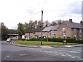
10
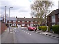
Lyndene Road joins Hartsbourne Avenue
Image: © Raymond Knapman
Taken: 24 Apr 2012
0.20 miles