IMAGES TAKEN NEAR TO
Hartsbourne Avenue, LIVERPOOL, L25 1RY
Introduction
This page details the photographs taken nearby to Hartsbourne Avenue, L25 1RY by members of the Geograph project.
The Geograph project started in 2005 with the aim of publishing, organising and preserving representative images for every square kilometre of Great Britain, Ireland and the Isle of Man.

There are currently over 7.5m images from over14,400 individuals and you can help contribute to the project by visiting https://www.geograph.org.uk
Image Map
Images are licensed for reuse under creativecommons.org/licenses/by-sa/2.0
Notes
- Clicking on the map will re-center to the selected point.
- The higher the marker number, the further away the image location is from the centre of the postcode.
Image Listing (19 Images Found)
Images are licensed for reuse under creativecommons.org/licenses/by-sa/2.0
Image
Details
Distance
1
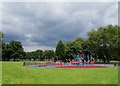
Childwall Valley Children's Play Area
Children's play area in Childwall Valley recreation ground near Jackson's Pond Drive. In the dim and distant past, water flowed here from a spring and was collected in a cistern pit known locally as Jackson's Pond, a popular place for local children to fish. 'Jackson's Pond Drive' is a few hundred metres from the actual location of Jackson's Pond which is where the 'Alderman John Village Garden' is now located https://www.geograph.org.uk/photo/6466387. See old map here https://maps.nls.uk/geo/explore/side-by-side/?zoom=17&lat=53.39727&lon=-2.87461&layers=168&right=BingHyb#zoom=17&lat=53.39490&lon=-2.87461&layers=6&right=OSAPI
Image: © Sue Adair
Taken: 14 Jul 2019
0.08 miles
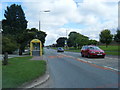
3
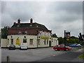
The Coronation is no more!
The Coronation pub on Childwall Valley Road just before demolition in Autumn 2010.
Image: © Sue Adair
Taken: 4 Aug 2010
0.14 miles
5
Childwall Valley Road and Trans Pennine Trail
Disused railway bridge carrying the National Cycleway Network Route 62 (Trans Pennine Trail) over Childwall Valley Road. The Trans Pennine Trail is an long distance route for walkers, cyclists and horse riders that links the North and Irish seas. Originally part of the Cheshire Lines Committee's North Liverpool Extension Line which connected its main Liverpool to Manchester line to the north Liverpool docks at Huskisson by skirting through agricultural land to the east of Liverpool. The last goods train ran in August 1975.
Image: © Sue Adair
Taken: 26 Mar 2009
0.17 miles
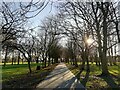
6
Footpath near Childwall Valley Road
Coming out from Wellgreen Road.
Image: © Bill Boaden
Taken: 24 Apr 2019
0.18 miles
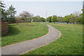
7
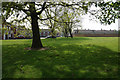
Winter Sunshine in Court Hey Park
Court Hey Park was formerly part of Lord Derby's Estate. In 1836 the grounds were acquired by the elder brother of Prime Minister William Gladstone, Robertson Gladstone (1805-1875) who built Court Hey, a mansion house in a sixty acre walled estate.
Image: © Sue Adair
Taken: 24 Dec 2020
0.18 miles
8
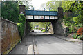
Old railway bridge over Well Lane
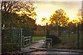
The railway was the Liverpool Loop Line and the bridge now carries the Transpennine Trail.
Image: © Bill Boaden
Taken: 24 Apr 2019
0.18 miles
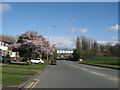
9
Green space by Timberland Close
There is a lot of green space all along the length of Childwall Valley Road, from where this is viewed.
Image: © Bill Boaden
Taken: 24 Apr 2019
0.19 miles