IMAGES TAKEN NEAR TO
East Damwood Road, LIVERPOOL, L24 7RQ
Introduction
This page details the photographs taken nearby to East Damwood Road, L24 7RQ by members of the Geograph project.
The Geograph project started in 2005 with the aim of publishing, organising and preserving representative images for every square kilometre of Great Britain, Ireland and the Isle of Man.

There are currently over 7.5m images from over14,400 individuals and you can help contribute to the project by visiting https://www.geograph.org.uk
Image Map
Images are licensed for reuse under creativecommons.org/licenses/by-sa/2.0
Notes
- Clicking on the map will re-center to the selected point.
- The higher the marker number, the further away the image location is from the centre of the postcode.
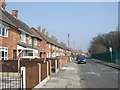
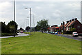
Image Listing (8 Images Found)
Images are licensed for reuse under creativecommons.org/licenses/by-sa/2.0
Image
Details
Distance
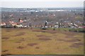
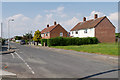
2
Junction with Almeda Road
Edge of housing estate on the Trans-Pennine Trail.
Image: © Row17
Taken: 19 Jun 2009
0.07 miles
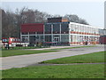
4
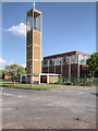
Speke, Church of St Ambrose
Roman Catholic Church built 1959-61; Grade II-listed (List Entry Number: 1393741 http://www.heritagegateway.org.uk/Gateway/Results_Single.aspx?uid=1393741&resourceID=5 Heritage Gateway).
Image: © David Dixon
Taken: 5 Jun 2016
0.12 miles