IMAGES TAKEN NEAR TO
Hillary Drive, LIVERPOOL, L23 9SY
Introduction
This page details the photographs taken nearby to Hillary Drive, L23 9SY by members of the Geograph project.
The Geograph project started in 2005 with the aim of publishing, organising and preserving representative images for every square kilometre of Great Britain, Ireland and the Isle of Man.

There are currently over 7.5m images from over14,400 individuals and you can help contribute to the project by visiting https://www.geograph.org.uk
Image Map
Images are licensed for reuse under creativecommons.org/licenses/by-sa/2.0
Notes
- Clicking on the map will re-center to the selected point.
- The higher the marker number, the further away the image location is from the centre of the postcode.
Image Listing (6 Images Found)
Images are licensed for reuse under creativecommons.org/licenses/by-sa/2.0
Image
Details
Distance
1
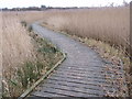
Boardwalk
Boardwalk covering Rimrose Brook, Rimrose Valley Country Park.
Image: © Norman Caesar
Taken: 24 Dec 2011
0.15 miles
2
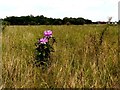
Self seeded Rhododendron
This self seeded Rhododendron appears to be the only one in Rimrose Valley Country Park
Image: © Norman Caesar
Taken: 25 May 2017
0.20 miles
3
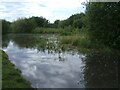
Rimrose Pond
Rimrose Pond, Rimrose Valley, Crosby, Merseyside
Image: © Jim Nolan
Taken: 4 Jun 2006
0.21 miles
5
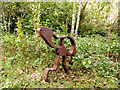
Iron art work. Rimrose Valley Country Park
Image: © Norman Caesar
Taken: 9 Oct 2016
0.23 miles