IMAGES TAKEN NEAR TO
Richard Road, LIVERPOOL, L23 8TF
Introduction
This page details the photographs taken nearby to Richard Road, L23 8TF by members of the Geograph project.
The Geograph project started in 2005 with the aim of publishing, organising and preserving representative images for every square kilometre of Great Britain, Ireland and the Isle of Man.

There are currently over 7.5m images from over14,400 individuals and you can help contribute to the project by visiting https://www.geograph.org.uk
Image Map
Images are licensed for reuse under creativecommons.org/licenses/by-sa/2.0
Notes
- Clicking on the map will re-center to the selected point.
- The higher the marker number, the further away the image location is from the centre of the postcode.
Image Listing (71 Images Found)
Images are licensed for reuse under creativecommons.org/licenses/by-sa/2.0
Image
Details
Distance
2
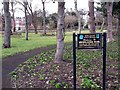
Merrilocks Garden
A small garden at the junction of The Serpentine North and Merrilocks Road.
Image: © Norman Caesar
Taken: 26 Jan 2012
0.07 miles
3
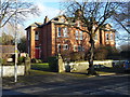
Victorian housing in Merrilock Road
The first housing is shown on the 1893 mapping and backs onto the L & Y.R. Liverpool, Crosby and Southport line.
Image: © John M
Taken: 17 Feb 2018
0.09 miles
4
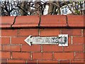
To the shore
This old sign is on the corner of Hall Road West and the entrance to West Lancs Golf Club
Image: © Norman Caesar
Taken: 27 Jan 2014
0.09 miles
6
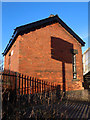
Railway building alongside Hall Road Station, Blundellsands
A small railway building alongside Hall Road railway station. There is an Ordnance Survey bench mark on this end wall, partially disguised here by the shadow of the railings: Image
Image: © John S Turner
Taken: 20 Jan 2020
0.13 miles
7
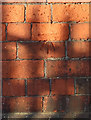
Bench mark on railway building, Hall Road Station
This Ordnance Survey bench mark is on the small railway building, just west of Hall Road Station. See also: Image
Image: © John S Turner
Taken: 20 Jan 2020
0.13 miles
8
Hall Road Station
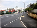
Hall Road Railway Station is located on the Southport branch of the Merseyrail network's Northern Line. It serves the Blundellsands area. The station first opened in 1874 as an intermediate station on the Lancashire and Yorkshire Railway (LYR).
Image: © David Dixon
Taken: 7 May 2016
0.13 miles
9
New housing estate
A small housing estate of 4 and 5 bedroom homes has been built between Hall Road station and West Lancs Golf Club
Image: © Norman Caesar
Taken: 10 Feb 2019
0.13 miles
10
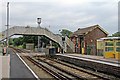
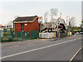
Footbridge and Building, Hall Road Railway Station
A station building adjacent to the northbound platform, in front of which is signal ML90. The footbridge is in front of Hall Road level crossing.
Image: © El Pollock
Taken: 13 Jun 2012
0.14 miles