IMAGES TAKEN NEAR TO
Dowhills Park, LIVERPOOL, L23 8ST
Introduction
This page details the photographs taken nearby to Dowhills Park, L23 8ST by members of the Geograph project.
The Geograph project started in 2005 with the aim of publishing, organising and preserving representative images for every square kilometre of Great Britain, Ireland and the Isle of Man.

There are currently over 7.5m images from over14,400 individuals and you can help contribute to the project by visiting https://www.geograph.org.uk
Image Map
Images are licensed for reuse under creativecommons.org/licenses/by-sa/2.0
Notes
- Clicking on the map will re-center to the selected point.
- The higher the marker number, the further away the image location is from the centre of the postcode.
Image Listing (39 Images Found)
Images are licensed for reuse under creativecommons.org/licenses/by-sa/2.0
Image
Details
Distance
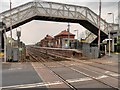
1
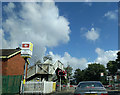
Waiting at the level crossing at Hall Road station
Image: © Rob Purvis
Taken: 8 Aug 2016
0.03 miles
4
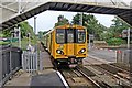
Leaving Hall Road Railway Station
Merseyrail unit 508108 travels beneath the footbridge, and over the Hall Road level crossing, at Hall Road railway station, whilst continuing the journey to Hunts Cross.
Image: © El Pollock
Taken: 13 Jun 2012
0.04 miles
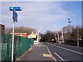
5
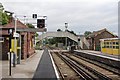
Signals and Footbridge, Hall Road Railway Station
Signal ML88 is nearest, on the southbound side, signal ML90 is on the opposite platform. Behind the footbridge is Hall Road level crossing.
Image: © El Pollock
Taken: 13 Jun 2012
0.04 miles
6
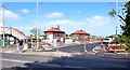
New car park at Hall Road Station is almost ready for use
Image: © Norman Caesar
Taken: 8 May 2017
0.04 miles
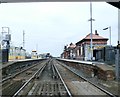
7
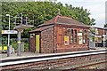
Ticket Office, Hall Road Railway Station
Situated on the southbound platform, next to the footbridge.
Image: © El Pollock
Taken: 13 Jun 2012
0.04 miles
8
Hall Road Railway Station
Hall Road Railway Station is located on the Southport branch of the Merseyrail network's Northern Line. It serves the Blundellsands area. The station first opened in 1874 as an intermediate station on the Lancashire and Yorkshire Railway (LYR).
Image: © David Dixon
Taken: 7 May 2016
0.04 miles
9
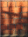
Bench mark on railway building, Hall Road Station
This Ordnance Survey bench mark is on the small railway building, just west of Hall Road Station. See also: Image
Image: © John S Turner
Taken: 20 Jan 2020
0.05 miles
10
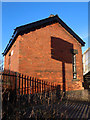
Railway building alongside Hall Road Station, Blundellsands
A small railway building alongside Hall Road railway station. There is an Ordnance Survey bench mark on this end wall, partially disguised here by the shadow of the railings: Image
Image: © John S Turner
Taken: 20 Jan 2020
0.05 miles