IMAGES TAKEN NEAR TO
Alexandra Road, LIVERPOOL, L23 7TG
Introduction
This page details the photographs taken nearby to Alexandra Road, L23 7TG by members of the Geograph project.
The Geograph project started in 2005 with the aim of publishing, organising and preserving representative images for every square kilometre of Great Britain, Ireland and the Isle of Man.

There are currently over 7.5m images from over14,400 individuals and you can help contribute to the project by visiting https://www.geograph.org.uk
Image Map
Images are licensed for reuse under creativecommons.org/licenses/by-sa/2.0
Notes
- Clicking on the map will re-center to the selected point.
- The higher the marker number, the further away the image location is from the centre of the postcode.
Image Listing (75 Images Found)
Images are licensed for reuse under creativecommons.org/licenses/by-sa/2.0
Image
Details
Distance
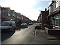
3

A row of 4 cottages set at right angles to Victoria Road
Image: © Norman Caesar
Taken: 12 Jan 2013
0.08 miles
5
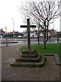
Cross over St. Michael's Well, Crosby
The name Crosby is derived from the Norse word "Kross" meaning Cross and the Scandinavian word "Bye" meaning village.
Image: © Norman Caesar
Taken: 21 Nov 2011
0.09 miles
6
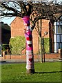
Valentine Decoration 5
Crocheted art work known as "yarn bombing"
Image: © Norman Caesar
Taken: 16 Feb 2014
0.09 miles
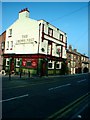
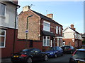
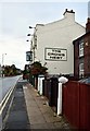
9
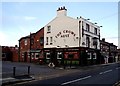
The Crows Nest public house, Victoria Road
Image: © Norman Caesar
Taken: 12 Jan 2013
0.10 miles
10

Valentine decoration 3
Crocheted art work known as "yarn bombing"
Image: © Norman Caesar
Taken: 16 Feb 2014
0.10 miles