IMAGES TAKEN NEAR TO
Weld Road, LIVERPOOL, L23 6RJ
Introduction
This page details the photographs taken nearby to Weld Road, L23 6RJ by members of the Geograph project.
The Geograph project started in 2005 with the aim of publishing, organising and preserving representative images for every square kilometre of Great Britain, Ireland and the Isle of Man.

There are currently over 7.5m images from over14,400 individuals and you can help contribute to the project by visiting https://www.geograph.org.uk
Image Map
Images are licensed for reuse under creativecommons.org/licenses/by-sa/2.0
Notes
- Clicking on the map will re-center to the selected point.
- The higher the marker number, the further away the image location is from the centre of the postcode.
Image Listing (84 Images Found)
Images are licensed for reuse under creativecommons.org/licenses/by-sa/2.0
Image
Details
Distance
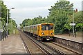
1
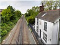
The Merseyrail Northern Line at Crosby
Looking north from Mersey Road.
Image: © David Dixon
Taken: 13 May 2016
0.05 miles
2
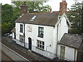
Cottage beside the railway
A neat white cottage just south of Blundellsands and Crosby Station. There seems to be a plaque above the door but I could not make out the inscription. Taken from the road bridge over the railway.
Image: © Karl and Ali
Taken: 4 Jun 2014
0.06 miles
3
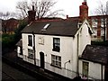
The old station masters' house for Blundellsands and Crosby Railway Station
Image: © Norman Caesar
Taken: 21 Dec 2011
0.06 miles
4
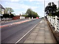
Mersey Road
Bridge over the railway track at Mersey Road.
Image: © David Dixon
Taken: 13 May 2016
0.07 miles
5
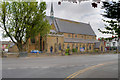
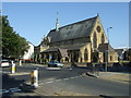
St Nicholas' Parish Church, Blundellsands
Construction of the present St Nicholas’ Church began in 1872 when its foundation stone was laid; it was consecrated just over a year later, on September 4th 1873. Originally it was to have had a fine spire, where the north porch now stands, but escalating costs eventually prevented this and the resulting building was relatively plain and modest. However, over the next twenty years, as the Parish grew and prospered, significant additions and alterations were made to create the present distinctive appearance of the church on the corner of Bridge Road and Mersey Road (https://stnicholasblundellsands.org/the-church/about-2/ History of St Nicholas’ Church).
The church, with its distinctive copper-clad fleche, is a grade II listed building (Historic England List Entry Number: 1257680 http://www.heritagegateway.org.uk/Gateway/Results_Single.aspx?uid=1257680&resourceID=5 heritage Gateway).
Image: © David Dixon
Taken: 13 May 2016
0.08 miles
6
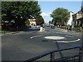
Roundabout, Blundellsands.
Bridge Road/Mersey Road junction mini-roundabout.
Image: © Colin Pyle
Taken: 13 Sep 2008
0.08 miles
7
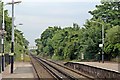
Looking South, Blundellsands and Crosby Railway Station
Mersey Road bridge is in the distance.
Image: © El Pollock
Taken: 13 Jun 2012
0.08 miles
8
Arriving at Blundellsands and Crosby Railway Station
Merseyrail unit 507007 arrives with the Hunts Cross to Southport service.
Image: © El Pollock
Taken: 13 Jun 2012
0.08 miles
9
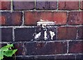
Benchmark Mersey Road
This benchmark is on the top of the railway bridge near the entrance to steps leading to a railway path.
Image: © Norman Caesar
Taken: 3 Jul 2013
0.08 miles