IMAGES TAKEN NEAR TO
Coronation Road, LIVERPOOL, L23 5RQ
Introduction
This page details the photographs taken nearby to Coronation Road, L23 5RQ by members of the Geograph project.
The Geograph project started in 2005 with the aim of publishing, organising and preserving representative images for every square kilometre of Great Britain, Ireland and the Isle of Man.

There are currently over 7.5m images from over14,400 individuals and you can help contribute to the project by visiting https://www.geograph.org.uk
Image Map
Images are licensed for reuse under creativecommons.org/licenses/by-sa/2.0
Notes
- Clicking on the map will re-center to the selected point.
- The higher the marker number, the further away the image location is from the centre of the postcode.
Image Listing (85 Images Found)
Images are licensed for reuse under creativecommons.org/licenses/by-sa/2.0
Image
Details
Distance
1
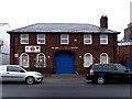
Drill Hall
This WW1 drill hall was originally the home of 7th Battalion, Kings Liverpool Regiment (E Company). It is now used as a Youth club
Image: © Norman Caesar
Taken: 25 Mar 2014
0.02 miles
2
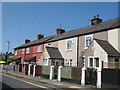
Vale Road Cottages
Cottages in Vale Road dated 1844, formerly named Alma Vale, these are some of the original habitations in Great Crosby before the expansion of the late 19th Century.
Image: © Sue Adair
Taken: 24 Jun 2020
0.06 miles
4
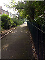
Pathway alongside Coronation Park
This pathway has limited access into Coronation Park
Image: © Norman Caesar
Taken: 19 Sep 2015
0.08 miles
5
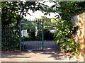
Gateway from St. Luke's road to pathway alongside Coronation Park
Image: © Norman Caesar
Taken: 19 Sep 2015
0.08 miles
6
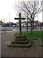
Cross over St. Michael's Well, Crosby
The name Crosby is derived from the Norse word "Kross" meaning Cross and the Scandinavian word "Bye" meaning village.
Image: © Norman Caesar
Taken: 21 Nov 2011
0.09 miles
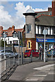
7
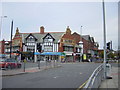
Crown Buildings, Crosby
Crosby takes its name from the Old Norse for village of the cross, settled in 900AD by Norsemen who came from the Isle of Man and Ireland. This ancient village was merely a cluster of cottages until the growth of industry and commerce in the 18th century encouraged many Liverpool businessmen to look to the coast north of the city to build their homes. Crosby shopping centre stands at the top of Liverpool Road, a mish-mash of architectural styles not all as pleasing to the eye as Crown Buildings.
Image: © Sue Adair
Taken: 29 Oct 2005
0.09 miles
8
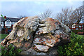
Glacial erratic - Coronation Park, Crosby
This gypsum erratic was found in 1898 20ft below the surface of a field in Cooks lane, Great Crosby. Its longitudinal axis lay at 48 degrees east of magnetic north. It was presented to Great Crosby Urban District Council by Edward Peters as 'a most remarkable relic of the glacial epoch'.
Image: © Gary Rogers
Taken: 18 Jan 2009
0.10 miles
9
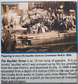
Coronation Park - detail from information board
A section of the panel shown here Image which gives some history about the origin and journey of the huge gypsum boulder.
Image: © Karl and Ali
Taken: 4 Jun 2014
0.10 miles
10
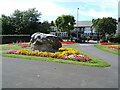
Glacier Stone
Stone found in Crosby Village and removed to Coronation Park
Image: © Jim Nolan
Taken: 14 Aug 2005
0.10 miles