IMAGES TAKEN NEAR TO
Virgins Lane, LIVERPOOL, L23 4UL
Introduction
This page details the photographs taken nearby to Virgins Lane, L23 4UL by members of the Geograph project.
The Geograph project started in 2005 with the aim of publishing, organising and preserving representative images for every square kilometre of Great Britain, Ireland and the Isle of Man.

There are currently over 7.5m images from over14,400 individuals and you can help contribute to the project by visiting https://www.geograph.org.uk
Image Map
Images are licensed for reuse under creativecommons.org/licenses/by-sa/2.0
Notes
- Clicking on the map will re-center to the selected point.
- The higher the marker number, the further away the image location is from the centre of the postcode.
Image Listing (15 Images Found)
Images are licensed for reuse under creativecommons.org/licenses/by-sa/2.0
Image
Details
Distance
1

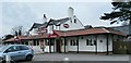
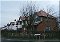
Crosby Hall Estate
Crosby Hall is located behind the trees on the skyline
Image: © Peter Hodge
Taken: 24 Dec 2005
0.03 miles

3
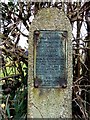
Commemorative Plaque
This plaque commemorates the coronation of Elizabeth II in June 1953.
Image: © Norman Caesar
Taken: 16 Mar 2014
0.07 miles
4
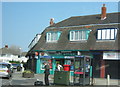
Thornton Post Office at 1 The Crescent
Image: © Peter Robinson
Taken: 24 May 2012
0.08 miles
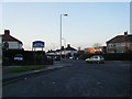
6
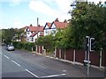
Housing at the corner of Park View and Green Lane
Image: © Anthony Parkes
Taken: 28 Dec 2015
0.18 miles
7
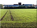
Holy Family Catholic High School, Thornton
Image: © Norman Caesar
Taken: 24 Oct 2013
0.20 miles
9
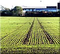
Holy Family Catholic High School, Thornton
Image: © Norman Caesar
Taken: 24 Oct 2013
0.20 miles